If you’ve ever unlocked your iPhone with your face, watched a self-driving car navigate busy streets, or seen a drone map a construction site — you’ve already benefited from LiDAR without even knowing it.
But what is LiDAR, exactly? How does it work? And why is everyone from Apple to NASA using it?
In this beginner-friendly guide, we’ll break down everything you need to know about LiDAR in plain, simple language — no engineering degree required.
What is LiDAR? (Simple Definition)
LiDAR stands for Light Detection and Ranging.
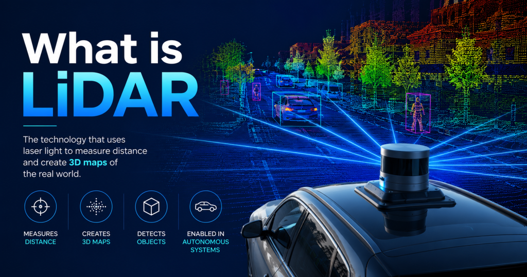
At its core, LiDAR is a technology that measures distances by firing laser pulses at objects and measuring how long it takes for the light to bounce back. Think of it like sonar on a submarine — except instead of sound waves bouncing off underwater objects, LiDAR uses light to “see” and measure the world around it.
The result? An incredibly detailed, real-time 3D map of the surrounding environment.
Simple analogy: Imagine you’re in a dark room and you clap your hands. You can roughly tell how big the room is by listening to the echo. LiDAR does the exact same thing — but with laser light, millions of times per second, with millimeter-level precision.
How Does LiDAR Work? Step-by-Step
Understanding LiDAR becomes very easy when you break it into four simple steps:
Step 1: Fire the Laser
A LiDAR sensor emits rapid pulses of laser light (usually infrared, invisible to the human eye) toward a target — whether that’s a road, a building, a face, or a forest floor.
Step 2: Light Hits an Object and Bounces Back
The laser light travels at the speed of light (about 299,792 km/s), hits a surface, and reflects back toward the sensor.
Step 3: Measure the Time of Flight
The sensor precisely records how long it took for the light to return. This is called Time of Flight (ToF). Since we know the speed of light, we can calculate the exact distance to that object using a simple formula:
Distance = (Speed of Light × Time of Flight) ÷ 2
The “÷ 2” is because the light travels to the object and back — so we divide by two to get the one-way distance.
Step 4: Build a 3D Point Cloud
The sensor does this millions of times per second, in every direction. Each returning pulse creates a single data point in space. Together, all these points form what’s called a point cloud — a dense, 3D digital map of the real world.
Imagine millions of tiny dots floating in space, each one representing a surface. When you connect them all, you get a highly accurate 3D model of everything around the sensor.
LiDAR vs. Radar vs. Camera — What’s the Difference?
You might be wondering: We already have cameras and radar. Why do we need LiDAR?
Great question. Here’s a quick comparison:
| Technology | How It Works | Strengths | Weaknesses |
|---|---|---|---|
| Camera | Captures light and color | Great detail, color | Can’t measure depth; fails in darkness |
| Radar | Uses radio waves | Works in rain/fog; measures speed | Low resolution; poor at fine detail |
| LiDAR | Uses laser pulses | Precise depth + 3D mapping | Expensive; struggles in heavy rain |
LiDAR fills the gap between cameras (which see detail but not depth) and radar (which measures distance but lacks resolution). This is why many modern technologies combine all three.
Real-World Examples of LiDAR in Action
Now let’s look at where you actually encounter LiDAR in the real world — some of these will surprise you!
iPhone Face ID — LiDAR in Your Pocket
Did you know your iPhone uses a form of LiDAR every time you unlock it?
Apple’s TrueDepth camera system (introduced with iPhone X) uses a dot projector combined with an infrared camera and proximity sensor — all based on time-of-flight depth sensing technology closely related to LiDAR principles.
When you hold up your phone, it fires 30,000 invisible infrared dots onto your face, measures how each dot distorts based on your facial contours, and creates a precise 3D depth map of your face in milliseconds.
Starting with the iPhone 12 Pro, Apple added a dedicated LiDAR Scanner to the rear camera system. This enables:
- Faster AR (Augmented Reality) — apps can place virtual furniture in your room almost instantly
- Improved Night Mode portraits — the LiDAR scanner helps focus in very low light
- Better object detection — apps can “see” the shape of your surroundings in real time
Self-Driving Cars — LiDAR as the “Eyes” of a Vehicle
This is probably the most talked-about use of LiDAR today.
Companies like Waymo, Tesla (debated), Cruise, and Mobileye rely heavily on LiDAR to help their vehicles understand the 3D world around them.
Here’s why LiDAR is so valuable for autonomous vehicles:
- It works in the dark. Unlike a camera, LiDAR doesn’t depend on ambient light. It creates its own illumination.
- It measures depth precisely. A camera might show you a pedestrian, but LiDAR tells the car exactly how far away that pedestrian is — down to centimeters.
- It creates a real-time 3D map. The car continuously builds a rotating 3D model of everything within 100–200 meters in every direction.
- It detects objects that cameras miss. A black car at night, a jaywalker in shadows — LiDAR sees them all.
Typical self-driving LiDAR systems spin 360 degrees and fire hundreds of thousands of laser pulses per second, creating a live, constantly-updating point cloud that the car’s AI uses to make split-second decisions.
Drones — Mapping from the Sky
LiDAR-equipped drones are quietly revolutionizing industries like agriculture, construction, archaeology, and forestry.
Here’s what they can do that normal camera drones can’t:
- See through vegetation. LiDAR pulses can penetrate gaps in forest canopy and map the ground beneath. Archaeologists have used drone LiDAR to discover entire hidden cities beneath jungle, including parts of the ancient Mayan civilization that were invisible from the air.
- Create precise topographic maps. Survey teams that used to take weeks mapping terrain on foot can now fly a drone over an area and have a centimeter-accurate 3D map in hours.
- Monitor crop health and field elevation. Farmers use LiDAR drone maps to understand water drainage patterns and soil variation across large fields.
- Inspect infrastructure. Power lines, bridges, and pipelines can be inspected safely and quickly without putting human workers at risk.
Construction and Architecture
Before a single brick is laid, modern construction sites use LiDAR to:
- Scan existing buildings and terrain to create precise “as-built” 3D models
- Monitor construction progress week by week
- Detect deviations from the original design plan
- Perform structural safety inspections on older buildings
Tools like Matterport use LiDAR (including the iPhone LiDAR scanner) to let real estate agents create fully navigable 3D walkthroughs of properties in minutes.
Environmental Science and Climate Monitoring
Scientists use airborne LiDAR systems to:
- Measure the height and density of forests to estimate carbon storage
- Track changes in glaciers and ice sheets over time
- Map floodplains and model where water will flow during storms
- Study coastal erosion by comparing LiDAR scans taken years apart
NASA has multiple LiDAR instruments in space, including the ICESat-2 satellite, which uses laser pulses to measure the height of Earth’s ice sheets with incredible precision to monitor climate change.
Types of LiDAR Systems
Not all LiDAR is the same. Here’s a quick overview of the main types:
Mechanical / Spinning LiDAR
The classic style — a rotating unit on top of self-driving cars that you’ve probably seen in photos. It spins 360 degrees and fires lasers in all directions. Great performance, but large and expensive.
Solid-State LiDAR
No moving parts. Uses electronic beam-steering instead of physical rotation. Smaller, cheaper, and more durable. This is what you’ll find in smartphones and newer automotive systems.
Airborne LiDAR
Mounted on aircraft or drones. Fires downward to map terrain. Used in surveying, archaeology, and environmental science.
Terrestrial LiDAR
Mounted on the ground or on a tripod. Used to scan buildings, construction sites, and industrial facilities from a fixed position.
A Brief History of LiDAR
LiDAR isn’t a new technology — it’s actually been around for over 60 years.
- 1960s — The first LiDAR systems were developed shortly after the invention of the laser. NASA used early LiDAR to map the Moon during the Apollo missions.
- 1970s–80s — LiDAR was used primarily for atmospheric research, measuring pollution, cloud cover, and wind patterns.
- 1990s–2000s — Airborne LiDAR became commercially available for land surveying and mapping.
- 2007 — The DARPA Urban Challenge brought LiDAR into the self-driving car spotlight, with teams using spinning LiDAR units to navigate autonomous vehicles through city streets.
- 2010s — LiDAR costs began to fall dramatically. Velodyne introduced the iconic spinning sensor seen on early Google self-driving cars.
- 2020 — Apple launched the iPhone 12 Pro with a built-in LiDAR scanner, bringing the technology to hundreds of millions of consumers for the first time.
- 2026 — LiDAR is now standard in premium smartphones, most autonomous vehicle platforms, and is rapidly being adopted across construction, agriculture, and public safety sectors.
How Much Does LiDAR Cost?
This is where things have changed dramatically.
In 2012, a high-end spinning LiDAR unit for a self-driving car could cost $75,000 or more. Today:
- Smartphone LiDAR (like in your iPhone) — included in the phone, functionally “free”
- Entry-level solid-state automotive LiDAR — $200–$1,000 per unit
- Mid-range drone LiDAR systems — $5,000–$20,000
- High-end spinning LiDAR (industrial/automotive) — $10,000–$75,000+
The dramatic price drop is one of the main reasons LiDAR is spreading so rapidly into consumer products and industries beyond automotive.
What Are the Limitations of LiDAR?
LiDAR is impressive, but it’s not perfect. Here are some real limitations:
- Weather sensitivity. Heavy rain, snow, or dense fog can scatter laser pulses and reduce accuracy significantly.
- Cost (still relative). While prices have dropped, high-end LiDAR systems are still expensive compared to cameras.
- No color information. LiDAR generates geometric data, not color. It can tell you the shape of an object, not what color it is. (This is why most systems combine LiDAR with cameras.)
- Privacy concerns. LiDAR systems used in public spaces can map people and buildings in extreme detail, raising legitimate privacy questions.
- Data volume. A single LiDAR sensor generates massive amounts of data per second, requiring significant computing power to process in real time.
The Future of LiDAR
The LiDAR industry is growing fast. Here’s what’s coming:
- Cheaper solid-state LiDAR will become standard in mid-range cars, not just luxury vehicles
- LiDAR in smart cities — streetlights and traffic infrastructure embedded with LiDAR sensors to monitor traffic flow and pedestrian safety
- Medical applications — LiDAR for gait analysis, rehabilitation monitoring, and surgery assistance
- Consumer AR/VR headsets — devices like the Apple Vision Pro use depth-sensing technology that builds directly on LiDAR advances
- Robotics — warehouse robots, delivery robots, and humanoid robots all rely on LiDAR-based depth sensing to navigate safely
Related Article: Mobile Robot Navigation with LiDAR: Simple Algorithms
Frequently Asked Questions About LiDAR
Q: Is LiDAR the same as radar?
No. Radar uses radio waves; LiDAR uses laser light pulses. LiDAR provides much higher resolution and is better for 3D mapping, but radar has advantages in bad weather and for detecting speed.
Q: Is LiDAR safe for human eyes?
Most consumer LiDAR devices (including in smartphones) use infrared wavelengths at power levels considered safe for eyes. Industrial and airborne systems follow strict safety standards. The laser pulses are extremely brief and low power.
Q: Does my iPhone have LiDAR?
If you have an iPhone 12 Pro, 12 Pro Max, or any iPhone 13/14/15/16 Pro model, yes — there’s a LiDAR scanner on the back camera. iPad Pro models from 2020 onward also have LiDAR.
Q: What software processes LiDAR data?
Popular tools include CloudCompare (free, open-source), Autodesk ReCap, ESRI ArcGIS, and DJI Terra for drone data. Developers often use Python libraries like Open3D or PCL (Point Cloud Library) to process LiDAR point cloud data programmatically.
Conclusion: Why LiDAR Matters
LiDAR has quietly become one of the most important sensing technologies of our era. From the phone in your pocket to the satellites orbiting Earth, it’s reshaping how machines perceive and interact with the physical world.
What is LiDAR? At its simplest: it’s technology that uses light to measure the world in three dimensions — faster, more accurately, and more reliably than almost any other method we have.
Whether you’re a curious beginner, a student, or a professional looking to understand the technology behind self-driving cars and AR apps, the core idea is beautifully simple: send a pulse of light, measure when it comes back, and you know exactly where everything is.
That’s LiDAR. And in 2026, it’s just getting started.

