The race to build safe, reliable self-driving cars has produced one of the most intense engineering debates in modern technology: which sensors should an autonomous vehicle use to perceive the world around it? The three main contenders are LiDAR (Light Detection and Ranging), radar, and cameras — and every major autonomous vehicle company has taken a different position on how to combine them, or whether to use all three at all.
At the center of this debate stands one of the most dramatic and public disagreements in the AV industry: Tesla versus Waymo. Tesla, under Elon Musk, has famously eliminated LiDAR from its vehicles entirely, calling it a “crutch” and insisting that cameras combined with AI are sufficient for full autonomy. Waymo, the autonomous vehicle subsidiary of Alphabet (Google’s parent company), has taken the opposite approach — deploying a comprehensive suite of LiDAR, radar, and cameras on every vehicle in its commercial robotaxi fleet.
Both companies have invested billions of dollars into their respective approaches. Both have compelling technical arguments. And the real-world results of their choices are now becoming clear through millions of autonomous miles, regulatory filings, and commercial deployments. This article breaks down exactly how each sensor works, what the data says about their strengths and limitations, and how to decide which combination is right for different applications.
If you want to understand the underlying technology behind these sensors, visit our detailed guide How Does LiDAR Work? Step-by-Step Explained at Lidarmos.com. And for the companies building next-generation sensor systems, see our Top LiDAR Startups 2025 article.
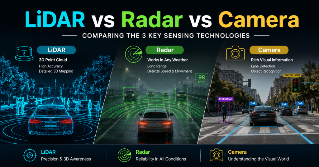
The Three Sensors: A Quick Overview
LiDAR — Light Detection and Ranging
LiDAR fires pulses of infrared laser light and measures the time each pulse takes to return after bouncing off an object. The result is a dense, precise 3D point cloud — a spatial map of the environment accurate to within 2–5 centimeters. Modern automotive LiDAR sensors generate between 100,000 and 2.4 million data points per second, providing a real-time 3D model of everything within 150–300 meters of the vehicle.
LiDAR is an active sensor — it generates its own illumination — so it works equally well in daylight and complete darkness. Its primary weaknesses are cost (still the most expensive of the three technologies, though prices have fallen over 90% since 2016) and sensitivity to dense fog and heavy rain, where laser light scatters off water droplets and reduces effective range.
Radar — Radio Detection and Ranging
Radar uses radio waves rather than light to detect objects. It has been used in automotive applications for decades in the form of adaptive cruise control and automatic emergency braking. Modern 4D imaging radar — used by companies like Continental, Arbe Robotics, and Waymo — extends traditional radar with much higher resolution and the ability to measure both range and velocity simultaneously through the Doppler effect.
Radar’s great strengths are its near-immunity to weather conditions (radio waves pass through rain, fog, dust, and smoke that would degrade both LiDAR and cameras), its native velocity detection, and its low cost. Its weakness is spatial resolution: even the best 4D radar systems produce far sparser and noisier spatial data than LiDAR, making fine-grained 3D scene reconstruction difficult.
Camera — Passive Visual Sensing
Cameras capture images of the world using visible light reflected from surfaces — the same way human eyes work. A single camera produces a 2D image with no direct depth information; depth must be computed either through stereo vision (two cameras at a known distance apart, triangulating depth from parallax) or estimated through AI-based monocular depth networks trained on millions of examples.
Cameras are the cheapest of the three technologies and provide the richest color and texture information — essential for reading road signs, recognizing lane markings, and distinguishing between a pedestrian and a mailbox. Their weakness is that they are passive sensors: they depend on ambient light to see, they struggle in low light and adverse weather, and computing 3D depth from 2D images adds latency and introduces estimation errors that direct-measurement sensors do not have.
Master Comparison: LiDAR vs Radar vs Camera
The table below provides a comprehensive 18-metric comparison across all three sensor technologies, covering accuracy, range, cost, weather performance, and operational characteristics:
| Metric | LiDAR | Radar | Camera |
| 3D Depth Accuracy | 2–5 cm typical; sub-1 cm with RTK | 10–50 cm; low spatial resolution | 5–50 cm via stereo; AI-estimated |
| Range (Max) | 150–300 m (automotive) | 200–500 m (long-range) | 50–150 m (clear conditions) |
| Range (Typical Use) | 80–200 m | 50–250 m | 30–100 m |
| Cost (Per Sensor, 2024) | $200 – $2,000 (mid-range automotive) | $50 – $500 | $5 – $200 |
| Full Sensor Suite Cost | $3,000 – $15,000 (multi-unit) | $500 – $2,000 | $500 – $3,000 |
| Heavy Rain Performance | Moderate — rain scatters laser | Excellent — unaffected by rain | Poor — lens fouling + reduced contrast |
| Dense Fog Performance | Poor — fog reflects strongly | Excellent — penetrates fog | Very poor — near-zero visibility |
| Bright Sunlight | Good — filtered to laser wavelength | Excellent — unaffected | Moderate — glare, bloom issues |
| Night / Darkness | Excellent — active illumination | Excellent — active illumination | Poor without IR — passive only |
| Velocity Detection | Only FMCW type (Aeva, Luminar) | Native Doppler — instant, precise | Optical flow — computed, delayed |
| Color / Texture Info | No | No | Yes — full RGB color |
| Object Classification | Shape-based — moderate | Very limited — blob detection | Excellent — trained neural nets |
| Angular Resolution (H) | 0.1° – 0.4° (very precise) | 1° – 10° (low) | 0.05° – 0.2° (very high) |
| Data Rate (Output) | 1–20 MB/s raw point cloud | Low — object list only | 30–150 MB/s (HD video stream) |
| Compute Requirements | High — point cloud processing | Low — simple signal processing | Very high — real-time CNN inference |
| Works Through Vegetation | Partial — multiple returns | Good — partial penetration | No |
| Regulatory Maturity | Medium — evolving standards | High — decades of automotive use | High — well-understood |
| Weight (Typical Module) | 0.2 – 2.5 kg | 0.1 – 0.5 kg | 0.05 – 0.3 kg |
Table 1: Comprehensive LiDAR vs Radar vs Camera comparison across 18 metrics — Automotive application context
Diagram 1: Sensor Detection Zones on a Self-Driving Vehicle (Top View)
FRONT
┌─────────────────────────┐
│ CAMERA (120° wide) │
│ ◄──────────────────► │ 0 – 150 m
│ │
RADAR │ ◄──────────────────► │ RADAR
(left │ LiDAR 360° CIRCLE │ (right)
wide) │ ╔═══════════════════╗ │ 0 – 300m
│ ║ [VEHICLE] ║ │
│ ║ (top view) ║ │
│ ╚═══════════════════╝ │
RADAR │ ◄──────────────────► │ RADAR
(left │ │ (right)
rear) │ CAMERA (rear 60°) │
│ ◄──────────────────► │ 0 – 80 m
└─────────────────────────┘
REAR
LEGEND:
═══ LiDAR FOV (360° horizontal; 2–5 cm accuracy; 0–200m)
─── Radar FOV (forward/rear long-range 0–500m; wide short-range)
··· Camera FOV (multiple focal lengths; color + classification)
Diagram 1: Typical sensor placement and field-of-view coverage on a Level 4 autonomous vehicle
Weather Performance: The Most Critical Real-World Factor
Weather performance is arguably the most important differentiator between these sensors for real-world autonomous driving, because a self-driving car must operate safely in all conditions — not just ideal ones. An autonomous vehicle that fails in rain is not commercially deployable across most of the world.
Diagram 3: Sensor Performance Across Weather Conditions
CONDITION LIDAR RADAR CAMERA
────────────────────────────────────────────────
Clear day ●●●●● ●●●●● ●●●●●
Night ●●●●● ●●●●● ●●○○○
Light rain ●●●●○ ●●●●● ●●●○○
Heavy rain ●●●○○ ●●●●● ●●○○○
Light fog ●●●○○ ●●●●● ●●●○○
Dense fog ●●○○○ ●●●●● ●○○○○
Snow (falling) ●●●○○ ●●●●○ ●●○○○
Snow (ground) ●●●●○ ●●●●● ●●●○○
Bright glare ●●●●● ●●●●● ●●●○○
Dust / sand ●●○○○ ●●●●● ●○○○○
● = Full performance ○ = Degraded / No data
Diagram 3: Qualitative sensor performance across different environmental conditions
Rain and Fog
Radar is the clear winner in adverse weather. Radio waves at the frequencies used in automotive radar (76–81 GHz) pass through water droplets in rain and fog with minimal attenuation, allowing radar to maintain full detection range in conditions that would effectively blind both LiDAR and cameras.
LiDAR is severely impacted by dense fog. Fog droplets are comparable in size to the wavelength of LiDAR lasers, causing strong backscattering — the laser light reflects off the fog itself rather than passing through to reach objects beyond. In heavy fog, effective LiDAR range can drop from 200 meters to as little as 20–30 meters. In heavy rain, the impact is significant but less severe than fog.
Cameras in fog lose contrast and produce hazy, low-information images. In heavy rain, lens fouling (water droplets on the lens) and reduced scene contrast combine to make camera-based perception unreliable. This is one of the core arguments for maintaining radar in any sensor suite intended for real-world commercial deployment.
Darkness and Night Driving
LiDAR is entirely unaffected by ambient light levels — it generates its own illumination and works identically at midnight as at noon. This is one of its most important advantages over cameras for autonomous driving applications. Radar similarly operates independently of ambient light.
Cameras without supplemental infrared illumination perform poorly in darkness. Human-visible headlights illuminate the scene to some degree, but low-light camera performance is significantly degraded compared to daylight conditions. This creates a fundamental asymmetry: the cheapest sensor (camera) is most vulnerable to the most common environmental challenge (nighttime driving), while the most expensive sensor (LiDAR) handles it perfectly.
Industry Data Point: Approximately 50% of fatal road accidents occur at night despite only 25% of total driving miles happening after dark. Reliable night perception is not optional for any system claiming meaningful safety improvement.
Tesla vs Waymo: Two Philosophies, One Destination
No comparison of AV sensors is complete without examining the most prominent real-world test of competing approaches: Tesla’s camera-first philosophy against Waymo’s sensor-fusion approach. These two companies have made fundamentally different bets about which technology path leads to safe, scalable autonomy.
| Comparison Point | Tesla (FSD) | Waymo (Driver) |
| Sensor Philosophy | Camera-only (“Tesla Vision”) | Full sensor fusion (LiDAR + Radar + Camera) |
| LiDAR | None — explicitly rejected | Multiple solid-state LiDAR units; Waymo Driver uses Jaguar I-PACE platforms with rooftop spinner + short-range units |
| Radar | Removed from Model 3/Y (2021); retained on S/X | 4D imaging radar for redundancy and weather |
| Cameras | 8 cameras, 360° coverage, 250m max range | 29 cameras (various focal lengths); 360° surround |
| Perception Approach | AI neural networks + computer vision only | Sensor fusion: LiDAR + camera + radar combined |
| HD Maps | No — real-time mapping only | Yes — pre-built and continuously updated HD maps |
| Operational Domain | Consumer vehicle (driver always present) | Robotaxi (fully driverless, no steering wheel) |
| Autonomy Level | SAE Level 2 (driver must supervise) | SAE Level 4 (fully autonomous in geofence) |
| Sensor Suite Cost (Est.) | ~$1,000 per vehicle | $50,000–$150,000 per vehicle (2023 estimates) |
| Miles Driven (2024) | ~5 billion cumulative (FSD Beta fleet) | ~22 million (Waymo One commercial fleet, 2024) |
| Disengagements | Not publicly disclosed | 0.07 per 1,000 miles (California DMV 2023 report) |
| Commercial Status | FSD available as $8K add-on; supervised only | Paid robotaxi service in Phoenix, SF, Austin |
Table 2: Tesla FSD vs Waymo Driver — sensor strategy, capability, and commercial status comparison
Diagram 2: Tesla vs Waymo Perception Philosophy
TESLA (FSD / Tesla Vision)
─────────────────────────────────────────
8x Cameras ──► Neural Net (Dojo) ──► Drive
No LiDAR AI training on Decision
No Radar* fleet footage
(* S/X retain radar; 3/Y camera-only)
Philosophy: If humans drive with eyes only,
AI cameras should be enough at scale.
WAYMO (Waymo Driver)
─────────────────────────────────────────
LiDAR ──┐
Radar ──┼──► Sensor Fusion ──► HD Map ──► Drive
Camera─-┘ (Waymo stack) Matching Decision
Philosophy: Redundant, complementary sensors
create fail-safe perception with no single point of failure.
KEY DIFFERENCE:
Tesla: Low cost | Mass market | Driver must supervise
Waymo: High cost | Robotaxi | Zero driver needed
Diagram 2: Fundamental perception philosophy difference between Tesla FSD and Waymo Driver
Tesla’s Camera-Only Argument
Elon Musk has made several high-profile arguments for eliminating LiDAR from Tesla’s vehicles. The core argument is that human drivers navigate successfully using only vision — two eyes, no LiDAR — so a sufficiently powerful AI system trained on enough visual data should also be able to drive using cameras alone. LiDAR, in this view, is an expensive crutch that adds cost and complexity without being fundamentally necessary.
Tesla’s practical advantage in this approach is scale. With over 5 billion cumulative miles of driving data from its fleet — far more than any other company — Tesla has trained its neural networks on an extraordinary diversity of real-world driving scenarios. The Dojo supercomputer, built specifically for processing this video training data, represents a multi-billion-dollar investment in the camera-AI approach.
The commercial case is also compelling: Tesla’s sensor suite costs approximately $1,000 per vehicle versus Waymo’s estimated $50,000–$150,000. This cost difference is the primary reason Tesla’s Full Self-Driving system can be offered as an $8,000 consumer add-on while Waymo’s robotaxi service requires a fully dedicated vehicle platform that is not consumer-purchasable.
Important Caveat: Tesla’s FSD is currently SAE Level 2 — the driver must remain attentive and ready to take control at all times. It is not an autonomous vehicle in the regulatory or commercial sense. Tesla has not yet received regulatory approval for unsupervised operation on public roads.
Waymo’s Sensor Fusion Argument
Waymo’s counterargument is safety redundancy. In a system designed to operate with zero driver backup, a single sensor failure cannot be allowed to cause an accident. By fusing LiDAR, radar, and cameras, Waymo creates a system where each sensor compensates for the others’ weaknesses. If fog degrades the LiDAR, radar maintains detection. If direct sunlight causes camera glare, LiDAR continues unaffected. The system never relies on any single data stream.
The performance evidence supports this approach at the current frontier. Waymo’s California DMV disengagement rate — the frequency with which the system required human intervention — was 0.07 per 1,000 miles in the 2023 annual report, among the lowest of any company filing data. The company has been operating a commercial paid robotaxi service in Phoenix since 2020 and expanded to San Francisco in 2023, accumulating over 22 million fully driverless miles as of 2024.
Waymo has also documented specific scenarios where LiDAR proved critical: detecting a stopped vehicle on a dark highway that cameras missed; identifying a pedestrian emerging from between parked cars in rain that would have degraded camera performance. These are precisely the edge cases — rare but potentially fatal — that safety engineers design for.
Which Approach is Winning?
The honest answer in 2025 is that both approaches have demonstrated success in their respective domains, but for different applications. Tesla has proven that camera-AI is viable for a Level 2 driver assistance system that reduces accidents and makes highway driving less fatiguing. Waymo has proven that sensor-fusion enables genuine Level 4 driverless operation in defined geographies.
The question is which approach will ultimately achieve true Level 4 or Level 5 autonomy in unrestricted environments. Tesla’s approach requires AI that is essentially perfect — that can handle every edge case a human driver could encounter using only visual information. Waymo’s approach requires sensor hardware prices to fall enough that the cost differential becomes commercially manageable for wider deployment.
Industry consensus, reflected in the sensor choices of most major AV programs outside Tesla — including Cruise, Mobileye, Aurora, Motional, and Zoox — aligns more closely with Waymo’s sensor-fusion philosophy. But Tesla’s fleet scale and the rapid improvement of AI-based perception mean this debate is far from over.
Scorecard: Sensor-by-Sensor Ratings
The following scorecard rates each sensor across 11 key criteria on a five-star scale to help visualize relative strengths at a glance:
| Criterion | LiDAR | Radar | Camera |
| Accuracy (spatial) | ★★★★★ | ★★☆☆☆ | ★★★☆☆ |
| Range | ★★★★☆ | ★★★★★ | ★★★☆☆ |
| Cost (lower = better) | ★★☆☆☆ | ★★★★★ | ★★★★☆ |
| Rain performance | ★★★☆☆ | ★★★★★ | ★★☆☆☆ |
| Fog performance | ★★☆☆☆ | ★★★★★ | ★☆☆☆☆ |
| Night / darkness | ★★★★★ | ★★★★★ | ★★☆☆☆ |
| Velocity detection | ★★☆☆☆ | ★★★★★ | ★★★☆☆ |
| Object classification | ★★★☆☆ | ★★☆☆☆ | ★★★★★ |
| Color / texture | ☆☆☆☆☆ | ☆☆☆☆☆ | ★★★★★ |
| Data richness | ★★★★☆ | ★★☆☆☆ | ★★★★★ |
| Compute simplicity | ★★★☆☆ | ★★★★★ | ★★☆☆☆ |
| TOTAL (out of 55) | 36 / 55 | 42 / 55 | 36 / 55 |
Table 3: Sensor performance scorecard — 5-star ratings across 11 key criteria (each sensor rated independently)
Reading this scorecard, the key insight is that no single sensor scores highest on all metrics. Radar leads on weather resilience and velocity detection. LiDAR leads on spatial accuracy. Cameras lead on object classification and data richness. This is precisely why the industry consensus has moved toward sensor fusion rather than single-sensor approaches — the strengths are genuinely complementary.
The Cost Trajectory: Is LiDAR Becoming Affordable?
One of the most important trends shaping this sensor debate is the dramatic and ongoing decline in LiDAR sensor costs. Understanding where prices have been — and where they are heading — is essential context for any long-term assessment of which sensor approach will dominate.
Historical Cost Decline
- 2010: Velodyne HDL-64E — $75,000 per unit (the sensor on the original Google self-driving car)
- 2016: Velodyne VLP-16 — $8,000 per unit (16-channel, rotating mechanical)
- 2019: First solid-state LiDAR under $1,000 (Luminar Iris, early production)
- 2021: Livox Mid-360 — $599; RPLIDAR S2 — $299 (consumer / DIY accessible)
- 2023: Ouster OS1 (automotive grade) — $1,500–$3,000 per unit in volume
- 2024: Aeva Atlas, Luminar Iris — automotive-grade sensors targeting $500 at volume
- 2025 target: Multiple manufacturers targeting sub-$200 solid-state LiDAR for high-volume automotive
The Path to Cost Parity
The primary driver of LiDAR cost reduction has been the shift from mechanical spinning sensors — which contain precision motors and moving parts that are expensive to manufacture and maintain — to solid-state designs using MEMS mirrors or OPA (Optical Phased Array) technology that can be manufactured on semiconductor production lines at scale.
At projected volumes of 1 million+ units per year — the scale of a major automotive OEM — analyst estimates suggest solid-state LiDAR could reach $100–$200 per unit within 3–5 years. At that price point, the cost argument against LiDAR in consumer vehicles becomes significantly weaker. The question is whether AI-camera approaches will have achieved sufficient safety performance before that cost crossover occurs.
Cost Context: A single human fatality in an automotive accident costs an OEM an average of $1M–$6M in liability, regulatory costs, and brand damage based on historical legal settlements. The business case for adding a $300 LiDAR sensor that prevents one accident per 10,000 vehicles is straightforward at those numbers.
Decision Guide: Which Sensor Combination is Right for You?
Given the complexity of the sensor landscape, making the right choice for a specific application requires matching sensor capabilities to application requirements. The following table provides a clear decision guide across ten common use cases:
| Use Case | Best Sensor Choice | Reason |
| Consumer car (human driver always present) | Camera + Radar | Low cost; FSD-style AI; driver supervises |
| Robotaxi / Level 4 autonomy | LiDAR + Camera + Radar | Safety redundancy; no driver fallback |
| Highway autonomous trucking | Radar + LiDAR + Camera | Long range; weather resilience; velocity data |
| Urban delivery robot (Nuro-style) | LiDAR + Camera | Precise 3D at low speed; compact environment |
| Warehouse / logistics robot | LiDAR (2D/3D) | Indoor GPS-denied; precise navigation |
| Mining / underground inspection drone | LiDAR (SLAM) | GPS-denied; 3D mapping; no camera needed |
| Agricultural autonomous tractor | LiDAR + Camera + RTK GPS | Terrain mapping + crop detection + positioning |
| Parking assist / low-speed ADAS | Radar + Ultrasonic + Camera | Short range; low cost; proven technology |
| Adverse weather (Arctic, fog, heavy rain) | Radar primary + LiDAR backup | Radar dominates; LiDAR supplements in clear moments |
| Budget DIY drone mapping project | Single LiDAR (LD06 / RPLIDAR) | Low cost; sufficient for small-site 3D mapping |
Table 4: Decision guide — recommended sensor combinations by autonomous vehicle application and use case
Key Questions to Ask Before Choosing
Use these five questions to narrow down the right sensor combination for any autonomous or semi-autonomous application:
- What is the safety consequence of a sensor failure? If a human is always present and can take over (Level 2), camera + radar is often sufficient. If no human fallback exists (Level 4), redundant sensors are necessary.
- What weather conditions will the system operate in? All-weather commercial deployment almost always requires radar. LiDAR-only systems are inadequate in dense fog or heavy rain.
- What is the maximum unit cost budget? Under $5,000 total sensor cost: camera + radar. $5,000–$20,000: add one LiDAR. $20,000+: full multi-LiDAR fusion suite.
- Is precise 3D mapping of the environment required? For HD map-based navigation, stockpile measurement, construction survey, or agricultural terrain modeling, LiDAR is essentially required. For object detection only (forward collision warning, lane keeping), camera + radar is often sufficient.
- Does the system need to detect the velocity of objects in real time? Doppler radar is the most reliable and cost-effective solution for native velocity detection. FMCW LiDAR (Aeva, Luminar) also provides this but at higher cost.
The Emerging Consensus: Sensor Fusion is the Standard
While the Tesla vs. Waymo debate generates headlines, the broader industry has largely converged on sensor fusion as the architectural standard for serious autonomous vehicle programs. Mobileye, which supplies ADAS technology to more than 50 automotive OEMs, uses cameras as its primary sensor but adds radar and, for its planned robotaxi platform (Mobileye Drive), LiDAR as well. Aurora’s commercial trucking program uses LiDAR, cameras, and radar. Zoox, Amazon’s autonomous vehicle subsidiary, uses all three.
The practical reason is insurance. When deploying a vehicle that will operate without human oversight and carry paying passengers or valuable cargo, a failure mode that causes a fatality is unacceptable. Single-sensor approaches — however sophisticated — have single-sensor failure modes. Fusion architectures degrade gracefully: if one sensor is compromised, the others continue providing safety-relevant data.
The Future: Where is This Heading?
4D Imaging Radar
One of the most significant developments in automotive sensing is the emergence of 4D imaging radar — radar systems with sufficient resolution to produce meaningful 3D point clouds, previously only achievable by LiDAR. Companies like Arbe Robotics, Metawave, and Vayyar are developing imaging radar that offers LiDAR-like resolution with radar-like weather immunity. If successful, 4D imaging radar could serve as a lower-cost, all-weather complement or even partial substitute for LiDAR in some applications.
AI-Enhanced Sensor Fusion
The next frontier is not choosing between sensors but using AI to optimally combine data from all of them in real time. Systems like Waymo’s sensor fusion stack and Mobileye’s REM (Road Experience Management) platform use machine learning to weight each sensor’s contribution based on current conditions — giving radar more influence in fog, cameras more influence for sign recognition, LiDAR more influence for precise positioning. As these fusion algorithms improve, the marginal value of each additional sensor increases.
The Role of HD Maps
High-definition maps — pre-surveyed, centimeter-accurate maps of road environments — represent a fourth data source that is often overlooked in sensor comparisons. Waymo’s system uses HD maps extensively: the vehicle’s LiDAR data is compared in real time to the pre-built HD map, and deviations (new obstacles, road changes) are detected as anomalies. This reduces the real-time perception burden on the sensor suite significantly.
Tesla explicitly rejects HD map dependency, arguing that any system requiring pre-mapped roads cannot scale globally. This is a legitimate concern: Waymo’s geofenced operation in Phoenix and San Francisco reflects the practical limits of HD map coverage. The tension between HD-map-dependent precision and scalable map-free operation is one of the defining strategic divisions in the AV industry.
Read more Interesting and informational Blogs Visit Our Website Lidarmos
Conclusion
After examining the data across accuracy, cost, weather performance, range, object classification, and real-world deployment results, the honest conclusion is that no single sensor technology is universally superior for self-driving car applications. Each has irreplaceable strengths and meaningful limitations, which is precisely why the industry’s best-funded and most safety-focused programs — Waymo, Aurora, Cruise, Mobileye Drive, Zoox — have all converged on multi-sensor fusion architectures.
LiDAR delivers unmatched spatial precision and reliable darkness performance, making it the foundation of any system that needs accurate 3D environmental mapping. Radar delivers all-weather reliability and native velocity detection that neither LiDAR nor cameras can match. Cameras deliver color, texture, and object classification capabilities that are essential for understanding complex, sign-rich road environments.
The Tesla vs. Waymo debate will continue, and both companies will likely influence the eventual shape of the industry. Tesla has proven that AI-camera systems can achieve commercially viable Level 2 performance at consumer price points. Waymo has proven that sensor fusion enables genuine Level 4 driverless commercial operation. These are not contradictory findings — they reflect different targets on the autonomy spectrum.
For anyone building or evaluating autonomous systems today, the most important guidance is: match your sensor architecture to your specific safety requirements, deployment environment, and cost constraints. Use our decision table in Section 7 as a starting framework, and remember that as LiDAR costs continue to fall toward the $200–$300 range, the economic case for excluding it from safety-critical applications becomes harder to justify.
For a deeper technical understanding of how LiDAR works at the physics level, see our How Does LiDAR Work? Step-by-Step Explained guide at Lidarmos.com. For the companies building the next generation of these sensor systems, our Top LiDAR Startups 2025 article covers Aeva, Exyn, Nuro, Outrider, and Agtonomy with real funding and technical data.

