Self-driving cars are no longer a distant dream. In 2026, robotaxis are operating in major cities across the United States, fully autonomous vehicles are expanding to new markets, and the technology behind them is becoming more powerful and affordable every year.
At the heart of most self-driving systems is LiDAR — Light Detection and Ranging. This laser-based sensing technology is what allows autonomous vehicles to “see” the world around them with incredible precision. But not every company uses LiDAR the same way. Some rely on it heavily. Others, like Tesla, have chosen a completely different path.
In this guide, you will learn exactly how self-driving cars use LiDAR, how the world’s top autonomous vehicle companies approach sensor technology, and where the industry is headed in 2026 and beyond.
What Is LiDAR and Why Do Self-Driving Cars Need It?
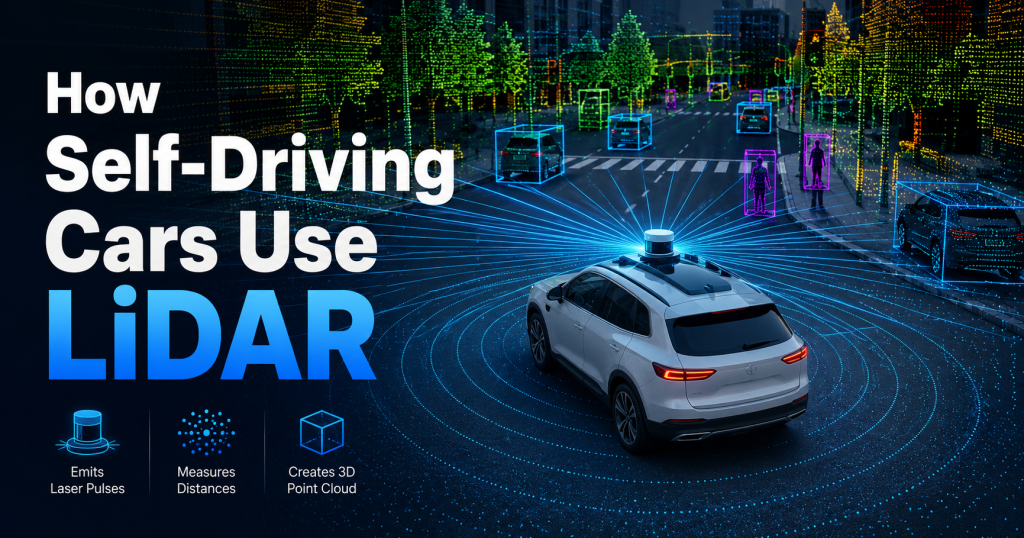
LiDAR is a remote sensing technology that works by firing rapid pulses of laser light at the surrounding environment. When those pulses hit an object — a car, a pedestrian, a traffic cone — they bounce back to the sensor. By measuring the time it takes for the laser to return, the system calculates the precise distance to every object in the scene.
This process happens millions of times per second. The result is a detailed, real-time 3D map called a point cloud — a dense cloud of data points that represents the vehicle’s entire surroundings.
For a self-driving car, this is critical. Human drivers use their eyes and brain to interpret the world visually. An autonomous vehicle needs sensors that can do the same job — or better — in all lighting conditions, at high speed, and with zero margin for error.
LiDAR gives self-driving cars three key capabilities:
- Precise distance measurement — accurate to within a few centimeters
- 360-degree awareness — sensors can cover the full area around the vehicle
- Reliable performance in darkness and poor weather — unlike cameras alone, LiDAR does not depend on visible light
Related Article: What is LiDAR? A Simple Beginner’s Guide (2026)
How LiDAR Works Inside a Self-Driving Car
Understanding how LiDAR fits into the full autonomous driving system helps explain why it matters so much.
Step 1: Sensor Data Collection
LiDAR sensors are typically mounted on the roof of the vehicle in a rotating unit, or placed at multiple fixed positions around the car. They continuously fire laser pulses in every direction, building a real-time 3D picture of everything within their range — from nearby pedestrians to objects 500 meters away.
Step 2: Point Cloud Generation
The returning laser signals are processed into a point cloud — a three-dimensional map made of millions of data points. Each point represents a surface reflection with an exact position in space. Together, they form a precise model of the vehicle’s environment.
Step 3: Sensor Fusion
No self-driving car relies on LiDAR alone. The point cloud data is combined with input from cameras, radar, and GPS in a process called sensor fusion. Each sensor type has different strengths:
| Sensor | Strength | Weakness |
|---|---|---|
| LiDAR | Precise 3D depth mapping | Cost, rain/fog performance |
| Camera | Color, texture, sign reading | Poor in darkness and glare |
| Radar | Works in all weather | Lower resolution |
| GPS | Global positioning | Not accurate enough for lanes |
By fusing all these inputs together, the system creates a complete and reliable picture of the world.
Step 4: Object Detection and Classification
AI algorithms analyze the fused sensor data in real time. The system identifies and classifies every object — cars, cyclists, pedestrians, animals, debris — and predicts how each one is likely to move. This happens continuously, hundreds of times per second.
Step 5: Path Planning and Decision Making
Based on the object detection results, the autonomous driving software decides the safest path forward. It calculates speed, lane position, when to brake, when to change lanes, and how to handle complex scenarios like intersections or construction zones.
Related Article: How Does LiDAR Work? Step-by-Step Explained
Waymo: The LiDAR Leader in 2026
Waymo, the autonomous driving subsidiary of Alphabet (Google’s parent company), is widely considered the most advanced robotaxi operator in the world. In 2026, Waymo is running fully autonomous commercial rides — with no human driver or remote operator — across multiple major US cities including San Francisco, Los Angeles, Phoenix, and Austin.
Waymo’s 6th-Generation Driver System
In February 2026, Waymo confirmed it had begun fully autonomous operations using its 6th-generation Waymo Driver — a major engineering milestone built on nearly 200 million fully autonomous miles of real-world driving experience.
The 6th-gen sensor suite is a significant refinement over previous versions:
| Sensor | 5th Generation | 6th Generation |
|---|---|---|
| Cameras | 29 | 13 (17-megapixel) |
| LiDAR units | 5 | 4 |
| Radar units | 6 | 6 |
| Total sensor reduction | — | 42% fewer sensors |
Despite using 42% fewer total sensors, Waymo says the new system delivers greater resolution, longer range, and improved compute power. This was made possible by higher-quality individual sensors — particularly the new 17-megapixel camera imager, which Waymo describes as “a generation ahead of other automotive cameras in resolution, dynamic range, and low-light sensitivity.”
How Waymo Places Its LiDAR Sensors
Waymo’s LiDAR units serve different purposes depending on their position:
- Roof-mounted long-range LiDAR — detects objects up to 500 meters away, enabling early identification of hazards at highway speeds
- Short-range LiDAR units — provide centimeter-level precision for close-up urban scenarios: pedestrians stepping off curbs, cyclists weaving through traffic, car doors opening suddenly
This combination of long-range awareness and close-range precision is what makes Waymo’s system capable of operating safely in complex city environments.
The 6th-gen Waymo Driver also features hydrophobic coatings and mechanical cleaning systems on all sensors to maintain performance in rain, snow, and dust.
Tesla: The Camera-Only Approach
Tesla is the most famous exception to the LiDAR-dependent model. Elon Musk has been a vocal critic of LiDAR for years, famously calling it a “crutch” and arguing that a vision-based system — cameras plus AI — is sufficient for full autonomy.
How Tesla’s FSD Works Without LiDAR
Tesla’s Full Self-Driving (FSD) system relies entirely on:
- 8 cameras surrounding the vehicle
- Ultrasonic sensors (some models)
- Radar (reintroduced on newer models)
- A powerful onboard AI chip (the Dojo-trained neural network)
Instead of building a precise 3D map from laser pulses, Tesla’s system learns to interpret the world from camera images — the same way human eyes work. The AI is trained on billions of miles of real-world driving data from Tesla’s massive global fleet.
Tesla’s Robotaxi and Cybercab in 2026
In 2026, Tesla launched its own robotaxi service, primarily using Model Y vehicles in Austin, Texas. Tesla has also rolled the first fully autonomous, steering-wheel-free Cybercab off its production line at Gigafactory Texas, with plans to expand the robotaxi program to seven new cities.
However, Tesla’s approach has faced scrutiny. Reports from early 2026 indicate that Tesla’s Austin robotaxi fleet has recorded 14 total incidents since the June 2025 launch — including collisions with a bus, a heavy truck, and fixed objects. Critics argue that removing LiDAR limits the system’s reliability in edge cases that cameras alone struggle to handle.
LiDAR vs Camera-Only: The Industry Debate
The debate between LiDAR-dependent and camera-only approaches is one of the most important discussions in autonomous vehicle development:
Arguments for LiDAR (Waymo’s approach):
- Provides direct, accurate 3D distance measurement that cameras cannot replicate
- Performs reliably in darkness, glare, and low-visibility conditions
- Ford CEO Jim Farley stated in June 2025: “LiDAR is mission critical”
- Research from Oliver Wyman concluded LiDAR is “likely to become the dominant solution for passenger cars” due to safety requirements
Arguments for Camera-Only (Tesla’s approach):
- Dramatically lower cost — Waymo’s Ojai vehicle is estimated at $70,000–$80,000; Tesla’s Cybercab is expected to cost roughly a quarter of that
- Scalable to mass-market vehicles without expensive sensor hardware
- Human drivers navigate successfully using only vision — Tesla argues AI can too
In practice, most serious autonomous vehicle programs — including Waymo, Cruise, WeRide, and Zoox — continue to rely on LiDAR as a core component of their sensor stack.
Other Major Players in 2026
Cruise (General Motors)
Cruise, GM’s autonomous vehicle division, also relies on a multi-sensor approach that includes LiDAR. Cruise vehicles use LiDAR for the same reasons as Waymo — precise 3D mapping and reliable all-condition performance. After facing setbacks in 2024, Cruise has been working to rebuild its safety reputation and expand operations in 2026.
WeRide
WeRide, a Chinese-American autonomous vehicle company, has expanded its operations in 2026. The company deployed its autonomous L4 Robobus at the Roland-Garros tennis tournament in Paris, operating as the exclusive autonomous shuttle service for the event. WeRide’s vehicles use LiDAR-based sensor fusion for reliable all-condition operation.
AEye
At the EAC 2026 Zhiyao Awards in Shanghai, AEye received the Smart Sensing Technology Innovation Award for its Apollo software-defined LiDAR sensor. The Apollo platform features an ultra-compact design capable of detecting objects at ranges up to one kilometer — designed specifically for commercial trucks and passenger vehicles.
LiDAR Sensor Placement in Self-Driving Cars
Understanding where LiDAR sensors are physically placed on a vehicle helps explain how autonomous systems achieve 360-degree awareness.
Common placement positions:
- Roof center — the most common location, providing a high vantage point and full 360-degree coverage; Waymo’s signature roof-mounted sensor unit sits here
- Front bumper — close-range detection for objects directly in front at low speeds
- Rear bumper — detection while reversing; helps avoid backing collisions
- Side mirrors / B-pillars — supplements coverage at intersections and for lane changes
- Under-vehicle — some systems use downward-facing sensors for precise ground-level detection
The exact placement varies by manufacturer and vehicle design. Waymo’s 6th-gen system uses four LiDAR units positioned to give overlapping fields of view all around the vehicle.
How LiDAR Enables Real-Time Mapping
One of the most remarkable capabilities of LiDAR in autonomous vehicles is real-time simultaneous mapping and localization — a technique known as SLAM (Simultaneous Localization and Mapping).
Here is how it works in a self-driving car:
- The vehicle uses pre-built high-definition maps of the road environment
- As it drives, LiDAR continuously scans the surroundings and matches what it sees to the stored map
- Any difference between the map and the real-world scan reveals changes — road works, new obstacles, parked vehicles
- The AI integrates this live data to determine the car’s exact position (within centimeters) and plan a safe path
This combination of detailed pre-mapped data and live LiDAR scanning is what allows Waymo vehicles to navigate complex urban environments with the precision required for fully driverless operation.
Challenges LiDAR Still Faces
Despite its advantages, LiDAR is not a perfect technology. Autonomous vehicle engineers continue to work on several key challenges:
Weather performance — rain, snow, fog, and dust can scatter laser pulses and reduce range. Waymo has addressed this with sensor cleaning systems and multi-sensor redundancy, but it remains an active area of development.
Cost — LiDAR sensors have become dramatically cheaper over the past five years, but they still add significant cost compared to cameras alone. This is one reason consumer vehicles with full LiDAR are not yet mainstream.
Computational load — processing millions of LiDAR data points per second requires substantial computing power. Advances in dedicated AI chips are helping reduce this challenge.
Reflective surfaces — highly reflective materials like mirrors or wet roads can produce false readings in some LiDAR systems.
The Future of LiDAR in Self-Driving Cars
The trajectory of LiDAR technology in 2026 is clearly upward — both in performance and affordability.
Key trends to watch:
- Solid-state LiDAR is replacing mechanical spinning units, reducing costs and improving durability. Companies like Innoviz, Luminar, and Hesai are leading this transition.
- Software-defined LiDAR — like AEye’s Apollo platform — allows sensor behavior to be updated through software, enabling continuous improvement without hardware changes.
- LiDAR + AI integration is accelerating. Machine learning algorithms are now capable of extracting significantly more information from LiDAR point clouds than was possible just a few years ago.
- Cost reduction continues — the LiDAR market, valued at $2.31 billion in 2024, is projected to reach $12.81 billion by 2033 as production scales and competition intensifies.
Ford has announced plans to introduce L3 “eyes-off” autonomous driving to affordable consumer vehicles by 2028, and the company has confirmed LiDAR will play a role in its sensor strategy.
Frequently Asked Questions
Do all self-driving cars use LiDAR?
No. Most autonomous vehicle companies — including Waymo, Cruise, and WeRide — rely heavily on LiDAR. Tesla is the most notable exception, using a camera-only approach with radar. Most industry experts consider LiDAR essential for achieving the highest levels of safety in fully autonomous driving.
How many LiDAR sensors does a self-driving car use?
It varies by system. Waymo’s 6th-generation Waymo Driver uses 4 LiDAR units, down from 5 in the previous generation. Earlier systems used as many as 8 or more. As sensor technology improves, fewer — but higher-quality — units are needed.
Can LiDAR work in rain and snow?
LiDAR performance can be affected by heavy rain, snow, and fog. Waymo addresses this with sensor cleaning systems, hydrophobic coatings, and multi-sensor redundancy. Radar is typically used to supplement LiDAR in poor weather conditions.
What is the range of LiDAR in a self-driving car?
Modern LiDAR systems used in autonomous vehicles can detect objects at ranges of 200 to 500 meters. Waymo’s 6th-gen system provides full 360-degree coverage up to 500 meters — day, night, and in adverse weather.
Why did Tesla choose not to use LiDAR?
Tesla’s approach is based on the belief that a vision-based AI system — trained on billions of miles of real-world data — can achieve safe autonomous driving without LiDAR. Tesla argues this approach is more scalable and cost-effective. Critics argue it sacrifices the safety redundancy that LiDAR provides.
Conclusion
LiDAR is the backbone of the world’s most advanced self-driving car systems in 2026. From Waymo’s refined 6th-generation sensor suite — capable of navigating complex cities across more than 10 US metropolitan areas — to the ongoing debate sparked by Tesla’s LiDAR-free philosophy, the role of laser sensing in autonomous vehicles remains central to the industry’s development.
As LiDAR technology continues to improve in range, reliability, and affordability, and as AI systems become better at interpreting the data those sensors generate, the path to truly safe, fully autonomous vehicles is becoming clearer.
Whether you are an engineer, a student, or simply someone curious about the cars of tomorrow, understanding how LiDAR works in self-driving vehicles gives you a front-row seat to one of the most significant technological transitions of our time.

