Imagine you are a wheat farmer in Punjab. You have 150 acres to manage. Every season, you walk your fields and try to guess where the soil is uneven, where water is pooling, which patches of crop are lagging behind, and where to spray next. You are making important decisions — decisions that affect your entire income for the year — based on what your eyes can see from ground level and what experience has taught you over decades.
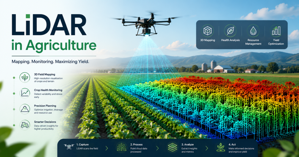
Now imagine a small drone flies over your entire farm in 20 minutes and hands you a precise, color-coded 3D map showing every centimeter of elevation change across your field, every area where crop height is below average, every low-lying zone where water will pool and damage roots, and a predicted yield estimate two months before harvest. No guesswork. No sampling bias. No missed patches.
That is what LiDAR agriculture looks like in 2026 — and it is no longer a technology reserved for large corporate farms in the United States or Europe. The cost of drone LiDAR systems has fallen dramatically, new Pakistani and regional agri-tech services are making these surveys available to mid-sized farms, and the data these systems produce is saving farmers real money by cutting water use, reducing chemical waste, and catching crop problems weeks before they become visible to the naked eye.
This article explains exactly how LiDAR drone farming works, what problems it solves for different crop types, what the technology costs in 2026, and how farmers in Pakistan and globally can start using it today. Whether you manage 20 acres or 2,000, there is a LiDAR agriculture solution that makes financial sense at your scale.
What is LiDAR? LiDAR stands for Light Detection and Ranging. A LiDAR sensor fires pulses of laser light and measures how long they take to bounce back — giving precise distance measurements. Mounted on a drone, it creates millions of 3D measurements of the land surface and crop canopy in a single flight. For the full technical explanation, see our How Does LiDAR Work? guide at Lidarmos.com.
Why Agriculture Needs LiDAR — The Real Problems It Solves
Before getting into the technology, it is worth being specific about what problems LiDAR actually solves on a farm. Because these are not hypothetical future problems — they are the exact challenges costing farmers money right now.
The Problem With Uneven Fields
Across most agricultural land in Pakistan and South Asia, fields are not perfectly flat. They have small variations in elevation — a rise of 15 centimeters here, a depression of 20 centimeters there — that are invisible to the naked eye but have enormous consequences for both irrigation and crop health.
In a rice paddy, a 10-centimeter difference in elevation means one area stays under 8 centimeters of water while an adjacent area has 18 centimeters. Too little water stresses the crop; too much drowns the roots and promotes fungal disease. In a wheat field, low spots accumulate excess water after rain, causing root rot in patches that can kill 5 to 15 percent of the yield in those areas. In a cotton field, uneven ground leads to uneven irrigation, which leads to uneven growth, which makes mechanical harvesting extremely difficult because the crop is at different stages in different parts of the field.
Laser land leveling — using a LiDAR-generated Digital Elevation Model to guide a laser-controlled scraper to flatten the field to within 2 centimeters across its full width — is already proven to reduce water consumption by 25 to 40 percent for irrigated rice. Studies conducted in Punjab by the International Water Management Institute (IWMI) found that laser-leveled rice fields use 25 percent less water per crop while producing 8 to 12 percent higher yields, because the crop receives more uniform irrigation.
Pakistan Data: Irrigation accounts for approximately 93% of all freshwater withdrawal in Pakistan. Even a 20% improvement in irrigation efficiency across major food crops would save billions of liters annually and reduce pressure on the Indus basin water system.
The Problem With Crop Monitoring at Scale
A farmer managing 100 acres cannot physically inspect every plant. Walking the field takes a full day and covers only what the eye can see at ground level. By the time a problem is visible from walking — a patch of yellowing leaves, a section of stunted growth, a developing pest infestation — it has often already spread significantly.
LiDAR changes the monitoring timeline. A drone flight over 100 acres takes 20 to 30 minutes and produces a complete map of crop canopy height across every square meter of the field. Healthy crops grow at a predictable rate; areas where canopy height is below the field average by more than 10 to 15 percent are flagged automatically as requiring attention. The farmer gets a GPS-mapped list of problem zones, can visit just those areas for ground-level diagnosis, and can respond with targeted intervention — not blanket treatment of the entire field.
The Problem With Chemical Waste
One of the most expensive and environmentally damaging practices in modern agriculture is uniform pesticide and fertilizer application. A farmer who knows that pests are present somewhere in a 200-acre cotton field will often spray the entire field as a precaution — because they have no reliable way to know exactly where the problem is concentrated. The result is that 60 to 80 percent of the chemical applied hits areas that did not need treatment, wasting money and damaging soil biology.
LiDAR-detected canopy density maps can identify zones where crop growth is abnormal — typically because pest or disease damage has reduced leaf density — and direct precise, variable-rate pesticide application only to those zones. When combined with multispectral imaging (which detects plant stress through changes in infrared reflectance), LiDAR gives an even more complete picture of exactly where in the field problems are occurring and how severe they are.
Diagram 1: LiDAR Drone Scanning a Farm Field (Side View)
[DRONE @ 50-80m altitude]
LiDAR spinning 360°
/ | \ | \
/ | \ | \
/ | \ | \ <- Laser beams
v v v v v
~~~~~~~~~~~~~~~~~~~~~~~~~~~~~~~~~~~ <- Crop canopy
Wheat / Rice / Cotton / Sugarcane
~~~~~~~~~~~~~~~~~~~~~~~~~~~~~~~~~~~
. . . . . . . . . . . . . . . . . <- Ground level
[SOIL][SOIL][LOW][HIGH][SOIL][SOIL] <- Terrain variation
DATA CAPTURED PER FLIGHT:
● Canopy height (cm accuracy)
● Ground elevation (soil surface map)
● Crop density (point cloud density)
● Water pooling zones (low-lying areas)
● Bare soil patches (missing/failed germination)
Flight time: 15-25 min | Area: 50-200 acres/flight
Diagram 1: LiDAR drone scanning a farm — capturing canopy height, terrain, and soil surface in one pass
The Four Main Uses of LiDAR in Agriculture
Crop Mapping and Canopy Analysis
Crop mapping is the most immediate and visually intuitive application of drone LiDAR farming. As a drone flies over a field, its LiDAR sensor measures the height of the crop canopy at millions of points. The result is a canopy height model — a precise measurement of how tall the crop is at every location in the field.
This sounds simple, but the information it contains is extraordinarily valuable. Crop height is one of the most reliable indicators of crop health and vigor. A field of wheat at 90 days should have a fairly uniform canopy height if growing conditions have been even. Areas where the canopy is significantly shorter than average indicate problems: poor germination, soil compaction, nutrient deficiency, pest damage, or waterlogging. Areas where the canopy is unusually dense may indicate lodging risk — where crops fall over before harvest — which causes significant losses in wheat and rice.
For orchard crops — mango, citrus, apple, guava — LiDAR canopy mapping provides three-dimensional volume measurements of individual tree crowns. This data is used to estimate fruit yield per tree before harvest, plan mechanized pruning operations, assess canopy light penetration (which directly affects fruit quality and color), and identify trees that are underperforming relative to the rest of the orchard.
In sugarcane — Pakistan’s third-most important crop — LiDAR canopy height measurements at different growth stages allow farmers to predict cane length and sucrose content weeks before harvest. Mills can use this data to schedule harvests, coordinate transport, and optimize crushing operations, reducing the enormous waste that occurs when cane is harvested at suboptimal maturity.
Soil Analysis and Digital Elevation Mapping
Before planting, and between crop seasons, LiDAR surveys of bare soil produce a Digital Elevation Model (DEM) — a centimeter-accurate 3D map of the field surface. This is the foundation for almost everything else that follows in precision agriculture, because knowing the exact topography of a field allows every subsequent decision to be made with spatial precision.
From a DEM, soil scientists and agronomists can calculate slope direction and magnitude at every point in the field, identify drainage patterns and water flow paths, delineate management zones with similar soil characteristics, identify areas of historical erosion or deposition, and plan the precise cut-and-fill operations needed for laser land leveling.
In Pakistan’s rice-growing areas of Sindh and central Punjab, DEM-based laser leveling is already in use through government and NGO programs, but adoption has been limited by the cost and availability of surveying equipment. As drone LiDAR survey services become available at Rs. 1,000 to 2,500 per acre (versus Rs. 3,000 to 8,000 per acre for traditional ground-based laser surveys), the economic case for soil mapping becomes compelling even for small and medium farms.
Beyond leveling, LiDAR DEMs reveal something that traditional soil testing cannot: the spatial pattern of soil variation across a field. Two soil test samples from a 50-acre field tell you the average composition of two small areas. A LiDAR-derived map of drainage patterns, erosion indicators, and elevation variation tells you the spatial structure of the entire field, allowing targeted soil sampling in areas most likely to have distinct characteristics.
Diagram 2: LiDAR Elevation Data for Irrigation Planning LIDAR DIGITAL ELEVATION MODEL (DEM) — Top View
─────────────────────────────────────────────────
HIGH ████████░░░░░░░░░░░░░░▓▓▓▓▓▓▓▓ HIGH
████████░░░░░░░░░░░░░░▓▓▓▓▓▓▓▓
MED ░░░░░░░░░░░░░░░░░░░░░░░░░░░░░░░ MED
░░░░░░░░░░░░░░░░░░░░░░░░░░░░░░░
LOW ▒▒▒▒▒▒▒▒▒▒▒▒▒▒▒▒▒▒▒▒▒▒▒▒▒▒▒▒▒▒ LOW ← Water pools here
▒▒▒▒▒▒▒▒▒▒▒▒▒▒▒▒▒▒▒▒▒▒▒▒▒▒▒▒▒▒
MED ░░░░░░░░░░░░░░░░░░░░░░░░░░░░░░░ MED
LEGEND: ████ = High ground ░░░░ = Medium ▒▒▒▒ = Low (flood risk)
IRRIGATION DECISIONS FROM THIS MAP:
▒▒▒▒ zones → Reduce irrigation (waterlogging risk)
████ zones → Increase irrigation (water drains away)
░░░░ zones → Standard irrigation schedule
RESULT: 25-35% water savings vs uniform irrigation
Diagram 2: LiDAR elevation map drives variable-rate irrigation — each zone gets exactly the water it needs
Irrigation Planning and Water Management
Water is the single most constrained agricultural resource in Pakistan. The Indus basin irrigation system is under severe stress, groundwater levels in central Punjab are dropping by 0.5 to 1 meter per year in many areas, and water theft and distribution inefficiency waste an estimated 40 to 60 percent of canal water before it reaches crops. In this context, any technology that improves on-farm water use efficiency has enormous value.
LiDAR-based irrigation planning works by using the field DEM to model exactly how water flows and distributes across the field surface. Low-lying areas receive more water than high areas under gravity-fed furrow irrigation, leading to waterlogging in depressions and under-irrigation on ridges. The LiDAR elevation map allows the farmer or agricultural engineer to redesign the irrigation layout — the position and slope of furrows, the location of water outlets, the sequence of irrigation — to achieve much more uniform water distribution.
For drip and sprinkler irrigation systems, LiDAR DEMs allow precise placement of emitters and calculation of optimal flow rates for each zone based on crop water demand and soil permeability estimated from terrain characteristics. Variable-rate irrigation controllers — which adjust flow rate zone by zone based on soil moisture sensors and the LiDAR elevation model — can reduce total irrigation water use by 30 to 45 percent compared to uniform application, with equal or better yield results.
In the context of Pakistan’s water crisis, where some areas now receive canal water allocations 30 to 40 percent below crop water requirements, the ability to use every available liter with maximum efficiency is not a luxury — it is a survival necessity for farming operations.
Yield Monitoring and Pre-Harvest Estimation
Predicting crop yield before harvest has traditionally been a matter of expert estimation — experienced farmers and agricultural extension officers walk fields and make educated guesses. These estimates are often used for marketing decisions, loan applications, insurance claims, and harvest logistics planning, and they are frequently wrong by 20 to 40 percent.
LiDAR-based yield estimation works by calculating the volume of the crop canopy at key growth stages and correlating it with harvest yield data from previous seasons. For row crops like wheat and rice, the relationship between canopy height, canopy density (measured by point cloud density within the canopy zone), and final grain yield is well-established in agricultural research.
A pre-harvest LiDAR survey at wheat grain-fill stage (around 100 days after sowing in Punjab conditions) can produce yield estimates accurate to within 8 to 15 percent of actual harvest — good enough to make meaningful marketing decisions. A farmer who knows that their wheat yield will be 15 percent above average can negotiate better prices or forward-contract their grain. A farmer who knows their yield will be below average can seek alternative income sources or delay grain sales in hope of better prices.
For insurance purposes, LiDAR yield estimation provides objective, documented evidence of crop condition before harvest — critical for crop insurance claims in cases of hail, flood, or drought damage, where disputes between farmers and insurance companies about the pre-damage crop condition are common.
LiDAR vs Traditional Farming Methods: Side-by-Side Comparison
The following table compares LiDAR agriculture methods with traditional approaches across six key farming tasks, with cost and outcome data relevant to Pakistan conditions:
| Farm Task | Traditional Method | LiDAR Agriculture Method | Improvement |
| Soil elevation survey | Manual GPS + total station
3-5 days per 100 acres Cost: Rs. 40,000-80,000 |
LiDAR drone flight
45 min per 100 acres Cost: Rs. 8,000-15,000 |
80% faster
70-75% cheaper |
| Crop height measurement | Manual sampling
100-200 random points Every 2-3 weeks |
LiDAR scan
Millions of points Every flight |
1000x more data
Full field coverage |
| Irrigation planning | Visual inspection
Farmer judgment Often incorrect |
DEM from LiDAR
Cm-accurate elevation Zone-based scheduling |
25-40% water saving
Scientific, not guesswork |
| Yield estimation | Harvest + weigh
(after the fact only) No prediction possible |
Canopy volume calculation
Pre-harvest estimate ±8-12% accuracy |
Advance planning
Market timing decisions |
| Drainage problem detection | Walk the field
Only visible when flooded Reactive approach |
Low-lying zone mapping
Visible before planting Preventive approach |
Prevents crop loss
Not just reports it |
| Weed/pest hotspot ID | Visual scouting
Partial coverage Labour intensive |
Canopy density anomaly
Full field in one flight GPS-tagged location |
Targeted spray only
30-50% pesticide cut |
Table 1: LiDAR agriculture vs traditional methods — task by task comparison with Pakistan-relevant cost estimates
Pakistan Focus: Which Crops Benefit Most and How
Pakistan’s agricultural sector contributes approximately 22 percent of GDP and employs nearly 37 percent of the workforce. The four major crops — wheat, rice, sugarcane, and cotton — along with fruit orchards in KPK and Balochistan, collectively represent the income of tens of millions of farming families. Here is specifically how LiDAR agriculture applies to each.
Diagram 3: LiDAR Agriculture Use Cases — Pakistan Context
PAKISTAN MAJOR CROPS + LIDAR BENEFIT
══════════════════════════════════════════════════════
WHEAT (Punjab, Sindh)
Problem: Uneven germination, waterlogging in low areas
LiDAR fix: DEM map → precision drainage → +12% yield
SUGARCANE (Punjab, KPK)
Problem: Labour-heavy crop monitoring, growth variation
LiDAR fix: Canopy height maps → spot underperformers
COTTON (Sindh, South Punjab)
Problem: Pest damage detection too late, wasted spray
LiDAR fix: Canopy density changes → early pest flag
RICE (Sindh, Punjab)
Problem: Flood field leveling costs Rs. 8,000+/acre
LiDAR fix: 2cm-accurate leveling → 30-40% water save
FRUITS (KPK, Balochistan orchards)
Problem: Rough terrain, no road mapping, crop loss
LiDAR fix: 3D orchard mapping → harvest route plan
AVERAGE ROI: Rs. 3,500-8,000/acre saved per season
Diagram 3: Pakistan’s major crops and specific LiDAR agriculture benefits for each
Wheat — Pakistan Most Important Crop
Wheat is grown on approximately 9 million hectares across Pakistan, primarily in Punjab and Sindh. The key LiDAR applications for wheat are field leveling before sowing (to ensure uniform germination and irrigation), canopy monitoring at tillering and jointing stages to identify stress zones, and pre-harvest yield estimation.
Research from the International Maize and Wheat Improvement Center (CIMMYT) trials in Punjab showed that precision field leveling based on LiDAR elevation data increased wheat yield by 8 to 12 percent compared to traditionally leveled fields, primarily through improved irrigation uniformity and reduced waterlogging in low spots. At current wheat prices of approximately Rs. 3,500 per 40 kg, a 10 percent yield improvement on a 50-acre wheat farm represents additional income of Rs. 50,000 to 70,000 per season.
Rice — The Water-Intensive Opportunity
Pakistan produces approximately 8 to 9 million tonnes of rice per season, with Sindh and southern Punjab as the primary growing regions. Rice cultivation is exceptionally water-intensive under traditional transplanted methods, requiring continuous flooding at precise depths throughout the growing season.
LiDAR-based laser leveling offers the most dramatic and well-documented benefits for rice among all crops. The IWMI study mentioned earlier demonstrated 25 percent water savings and 8 to 12 percent yield improvements from precise field leveling. For basmati rice, which commands premium export prices, uniform field conditions also improve grain uniformity and reduce the presence of chalk (immature grains) that downgrade export quality.
Cotton — Precision Pest and Stress Management
Cotton is Pakistan’s primary industrial crop and a critical source of export earnings. It is also extremely vulnerable to pest pressure — particularly from whitefly, pink bollworm, and thrips — that can devastate yields if not detected and treated quickly.
LiDAR canopy density mapping for cotton fields can detect the early signs of heavy pest infestation (reduced canopy density due to leaf damage and abscission) approximately 7 to 10 days before the damage becomes visible to field scouts. This early warning allows targeted pesticide application at lower rates, before pest populations explode. Trials in Sindh cotton belts have demonstrated 35 to 40 percent reductions in total pesticide applications when LiDAR-guided variable-rate spraying replaces blanket application.
Fruit Orchards — KPK and Balochistan
Pakistan’s fruit orchards — apple and cherry in Swat and Chitral, citrus in Sargodha, mango in Multan and Rahim Yar Khan, guava across Punjab — present a different set of LiDAR applications than field crops. Orchard trees are three-dimensional objects, and LiDAR’s ability to measure the full 3D structure of individual tree canopies provides information that two-dimensional remote sensing cannot match.
LiDAR orchard mapping measures individual tree crown volume, height, and canopy density across the entire orchard in a single drone flight. This data enables individual-tree yield estimation (identifying the trees that consistently underperform and should be replaced), pruning optimization (identifying canopy areas with insufficient light penetration), harvest scheduling (trees in different microclimates within the orchard may mature at different times), and access road planning for harvest machinery in challenging terrain.
Equipment Guide: What You Need for LiDAR Drone Farming
The equipment landscape for agricultural LiDAR has changed rapidly. In 2020, the minimum viable setup for drone LiDAR farming cost $30,000 or more. In 2026, meaningful farm-scale LiDAR surveys are achievable for $1,500 to $15,000 depending on the operation’s scale and data requirements.
| Equipment | Type | Price (USD) | Key Features for Agriculture |
| DJI Agras T50 | Fixed-wing spray drone | $14,000 | Built-in LiDAR obstacle avoid; spray automation; 50L tank; 40 acres/hr |
| DJI Zenmuse L2 | Survey payload (LiDAR) | $10,000 | 5-return LiDAR; 240m range; integrates with DJI Matrice 350 |
| Agronav Scout | Fixed-wing survey drone | $8,000 | LiDAR + RGB; 500-acre coverage per charge; terrain following |
| Slamtec RPLIDAR S2 | Standalone LiDAR sensor | $299 | 30m range; 32,000 pts/sec; DIY drone integration; good for small farms |
| Livox Mid-360 | 360° LiDAR payload | $599 | 40m range; 200K pts/sec; ideal for orchard canopy scanning |
| YellowScan Mapper+ | Professional survey | $45,000 | Multi-return; 75m AGL accuracy 2cm; full GIS data pipeline |
| Phantom 4 RTK + Lidar | Mid-range survey combo | $6,500 | RTK GPS + LiDAR mapping; good for 100-500 acre operations |
| Custom DIY build | Budget option | $800-1,500 | RPLIDAR A1/S2 + Pixhawk + F450 frame; see Lidarmos.com build guide |
Table 2: LiDAR drone equipment guide for agriculture — from DIY budget builds to professional survey systems
Getting Started Without Buying Equipment
For most farmers, the most practical first step is not buying equipment — it is hiring a drone LiDAR survey service. In Pakistan, agricultural drone survey services have expanded significantly since 2023, with providers now operating in major farming districts of Punjab and Sindh. A professional LiDAR survey of a 100-acre farm typically costs Rs. 80,000 to 150,000 and produces a complete DEM, canopy height model, and crop stress map with GPS accuracy.
This is dramatically cheaper than traditional ground-based survey alternatives, and the data products — delivered as GIS files and printable maps — can be used by any agronomist or farm manager without specialized technical knowledge. Many services also offer seasonal monitoring packages: three or four flights per season at key crop growth stages, with comparative analysis showing how the crop has developed between flights.
For farmers interested in building their own capability, our Low-Cost LiDAR Drone Build Guide at Lidarmos.com shows how to assemble a functional farm survey drone using an RPLIDAR sensor and a standard quadcopter frame for $800 to $1,500. This is well-suited to farms of 20 to 50 acres that want weekly monitoring capability without ongoing service fees.
Return on Investment: Does LiDAR Pay for Itself?
The most common question from farmers considering LiDAR agriculture is the one that matters most: will it make me more money than it costs? The honest answer depends on farm size, crop type, and how well the technology is implemented — but the numbers are increasingly favorable.
| Farm Size | Equipment Cost (Est.) | Annual Savings Breakdown | Total Annual Savings | Net Gain/Loss Yr 1 | Breakeven |
| Small farm (50 acres) | Rs. 75,000 | Rs. 12,000 saved water
Rs. 8,000 saved fertilizer Rs. 15,000 yield gain |
Rs. 35,000 | Rs. 40,000 | Year 2-3 |
| Medium farm (200 acres) | Rs. 180,000 | Rs. 55,000 saved water
Rs. 32,000 saved inputs Rs. 70,000 yield gain |
Rs. 157,000 | Rs. 23,000 | Year 1-2 |
| Large farm (500 acres) | Rs. 320,000 | Rs. 145,000 saved water
Rs. 85,000 saved inputs Rs. 190,000 yield gain |
Rs. 420,000 | Net +Rs. 100,000 | Year 1 |
| Shared/co-op (5 farms) | Rs. 180,000
(split 5 ways = Rs. 36,000 each) |
Rs. 35,000/farm saved
Shared equipment cost |
Rs. 175,000/farm | Net +Rs. 139,000/farm | Year 1 |
Table 3: LiDAR agriculture ROI estimate by farm size — Pakistan-context costs and savings (per season)
The ROI picture is clearest for large farms and for cooperative purchasing arrangements. A single large farm of 500 acres can recoup its LiDAR investment in the first season through water savings, reduced input costs, and yield improvements. Smaller farms face longer payback periods for owned equipment, but the co-operative model — where five to ten neighbouring farms share a drone system and rotate surveys — dramatically improves the economics for small and medium operations.
Pakistan Opportunity: Farm cooperatives and Farmer Producer Organizations (FPOs) under the Punjab Agriculture Department and KPK Agriculture Extension Service are ideal structures for shared LiDAR equipment ownership. A group of 10 farmers sharing a Rs. 180,000 drone system each pays Rs. 18,000 — less than the cost of a single traditional soil survey.
Water Saving Calculations
The water saving benefit alone is often sufficient to justify LiDAR investment for irrigated farms. At current Punjab tubewell electricity costs of approximately Rs. 12 to 18 per cubic meter of water pumped, a 30 percent reduction in irrigation water use on a 100-acre wheat-rice rotation farm saves approximately Rs. 40,000 to 65,000 per season in pumping costs alone — before accounting for any yield improvements.
Input Cost Reductions
Targeted pesticide application based on LiDAR-identified stress zones reduces chemical use by 30 to 50 percent on average in documented trials. At current pesticide prices — where a single spray application on 100 acres of cotton costs Rs. 20,000 to 35,000 for chemicals alone — eliminating two to three unnecessary whole-field applications per season saves Rs. 40,000 to 100,000 in chemical costs. The environmental benefit of reducing pesticide load on soil and water systems is additional.
Challenges and Honest Limitations
LiDAR agriculture is genuinely powerful, but it is important to be clear about what it cannot do and where the current challenges lie.
Data Without Expertise Is Just Data
A LiDAR survey produces maps. Those maps require agricultural knowledge to interpret correctly. A zone of below-average canopy height could indicate waterlogging, nutrient deficiency, pest pressure, poor seed quality, or soil compaction — and the correct response is different in each case. Without trained agronomists or extension workers to interpret the data in local crop and soil context, even the best LiDAR survey produces limited actionable benefit.
Building the local agronomic expertise to work with precision agriculture data is arguably the biggest barrier to LiDAR adoption in Pakistan. The hardware and software are becoming accessible; the agronomic interpretation layer is still underdeveloped. Agricultural universities and extension services need to integrate precision agriculture data literacy into their programs.
Regulatory Environment for Drones
Pakistan’s Civil Aviation Authority (CAA) regulates commercial drone operations. As of 2026, commercial drone surveys require CAA registration, operator certification, and in some areas, prior flight approval. The regulatory process has been streamlined compared to 2022, but it still adds time and cost to drone survey operations, particularly for small service providers trying to operate across multiple districts.
Farmers using survey services should verify that their service provider holds proper CAA authorizations. Flying without authorization creates legal risk and can result in equipment seizure.
Technology Is Not a Substitute for Good Agronomy
LiDAR agriculture is a decision-support tool, not a farming system. The technology tells you where problems are and approximately how severe they are. It cannot tell you why the problem occurred in that specific location, what the optimal treatment is given your soil type and local conditions, or what other management factors are interacting with the issue identified. Combining precision data with deep agronomic knowledge produces the best outcomes. Relying on data without ground-truthing and expert interpretation leads to confident but wrong decisions.
The Future of LiDAR Agriculture: What’s Coming by 2028
Autonomous Spray Drones with LiDAR Guidance
The next major development in drone farming LiDAR is the integration of LiDAR sensing directly into agricultural spray drones, enabling real-time variable-rate application during the spray flight itself. DJI’s Agras T50, already deployed in parts of Pakistan and India, uses LiDAR for obstacle avoidance and terrain following. The next generation of these systems will use real-time canopy density measurements from LiDAR to vary the spray rate across the field during the application — applying more chemical to dense canopy zones and less to sparse zones — in a single combined flight that both maps and treats.
AI Integration for Automatic Problem Detection
Current LiDAR agriculture workflows produce maps that agronomists interpret manually. The next wave of software platforms will automatically identify and classify anomalies in LiDAR data using machine learning models trained on large datasets of crop response. A farmer will upload their drone data and receive a report saying: “Zone A (GPS coordinates): likely waterlogging — 3 cm depression, drainage required. Zone B: likely iron deficiency based on canopy height pattern — soil test recommended.” This automation will make precision agriculture accessible to farmers without technical backgrounds.
Affordable Solid-State LiDAR for Small Drones
The single biggest barrier to widespread LiDAR adoption on small farms is the cost of the sensor. The shift from mechanical spinning LiDAR to solid-state designs — which are manufactured on semiconductor lines and can be produced in high volumes at low cost — is progressing rapidly. Analysts project that solid-state LiDAR sensors suitable for agricultural drone use will reach $100 to $150 per unit by 2027, making them practical components in consumer-grade agricultural drones priced below $2,000 total.
Conclusion
LiDAR agriculture is not a concept from a research paper or a technology that only large corporations can access. In 2026, it is a practical, commercially available set of tools that is already being used on farms across Asia, including in Pakistan, to solve real problems: uneven fields wasting water, pest infestations spreading undetected, crop stress going unnoticed until yield is already lost.
The investment case is clearest for water management. In a country where irrigation water is the binding constraint on agricultural productivity, and where on-farm water efficiency is chronically low, LiDAR-based field leveling and variable-rate irrigation planning offer returns that dwarf the technology cost within one to two seasons for most farm sizes.
For farmers not ready to invest in equipment, the practical first step is to hire a single LiDAR survey of one field, one season. Compare what the map shows you to what you thought you knew about that field. Talk to an agronomist about what the elevation and canopy data means for your specific crop and soil conditions. Experience the difference between managing a field with data and managing it with observation alone.
Agriculture has always advanced by giving farmers better information to make better decisions. LiDAR is one of the most powerful new information tools available to farmers in 2026. The question is not whether it will transform Pakistani agriculture — it is how quickly the tools, services, expertise, and financing arrive to make that transformation happen at the scale of the millions of farming families who need it most.
To learn more about the LiDAR technology behind these agricultural systems, see our How Does LiDAR Work? guide. To build your own farm survey drone, see our Low-Cost LiDAR Drone Build Guide.

