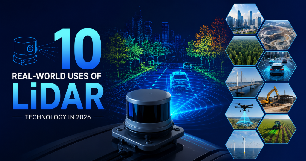
Here is a question: what does your iPhone, a Waymo self-driving taxi, an Amazon warehouse robot, and a NASA Mars rover all have in common?
They all use LiDAR.
LiDAR stands for Light Detection and Ranging. It works by firing tiny laser pulses and measuring how long they take to bounce back. Do this millions of times per second, and you get an incredibly accurate 3D map of everything around the sensor — accurate to just a few centimeters.
Ten years ago, LiDAR was rare and extremely expensive. A single sensor cost $75,000. Only the biggest technology companies could afford to use it. Today, you can buy a LiDAR sensor for $15. That price drop — 99.98% in less than 20 years — has opened the door for LiDAR to spread into almost every industry on Earth.
In this article, we count down the top 10 most exciting and important real-world uses of LiDAR technology in 2026. We will explain each one in simple language, give you real numbers and real examples, and show you why this technology is far more important to your daily life than most people realize.
Quick note: New to LiDAR? Before reading on, check out our beginner-friendly guide How Does LiDAR Work? Step-by-Step at Lidarmos.net. It explains the basic science in 5 minutes with easy diagrams.
Diagram 1: How LiDAR Works — Simple 5-Step Explanation
STEP 1 → Sensor fires a LASER PULSE (tiny beam of light)
STEP 2 → Laser hits an OBJECT (tree, car, building, ground)
STEP 3 → Light BOUNCES BACK to the sensor
STEP 4 → Sensor MEASURES THE TIME it took to return
STEP 5 → Computer calculates EXACT DISTANCE
(Distance = Speed of Light × Time ÷ 2)
Do this MILLIONS of times per second in all directions…
↓
You get a 3D POINT CLOUD — a precise map of everything
around the sensor, accurate to within 2-5 centimeters!
This is the technology behind ALL 10 uses in this article.
Diagram 1: LiDAR explained in 5 steps — the technology behind all 10 uses in this article
Quick Overview: All 10 Uses at a Glance
Before we go into detail, here is a quick summary table of all 10 uses. We will explain each one fully below.
| Use Case | Industry | Key Players | What LiDAR Does | Real-World Impact |
| #1 Self-Driving Cars | Autonomous vehicles | Waymo, Tesla, Mobileye | Detects every object around car in real-time 3D | 22M+ driverless miles (Waymo 2024) |
| #2 Archaeology | Heritage & research | PACUNAM, Univ. of Cambridge | Finds hidden cities under jungle | 61,000 new Maya structures found (2018) |
| #3 Agriculture | Farming & food | Agtonomy, DJI, Trimble | Maps crops, soil, irrigation zones from drones | 25-40% water saving; 8-12% yield gain |
| #4 Humanoid Robots | Manufacturing & AI | Boston Dynamics, Figure AI | Helps robots walk and avoid obstacles | 750,000+ Amazon warehouse robots use it |
| #5 Forestry | Environment & land | Govt agencies, forestry cos | Counts and measures trees from aircraft | Replaces 10 years of ground survey in 1 flight |
| #6 Construction | Building & civil eng. | Trimble, Leica, FARO | Tracks building progress; catches errors early | Saves $100K+ per project in rework costs |
| #7 Flood Control | Safety & government | NASA, USGS, local govts | Creates accurate flood risk maps from elevation | Saves thousands of lives per year globally |
| #8 Mining | Resources & industry | Exyn, Hexagon, Leica | Maps underground tunnels safely without people | Zero deaths from mapping accidents in LiDAR sites |
| #9 Smartphones | Consumer technology | Apple, Samsung | Powers Face ID and augmented reality features | 1.5 billion iPhone users use LiDAR every day |
| #10 Space Exploration | Science & NASA | NASA, ESA, JAXA | Maps Mars, Moon, asteroids in 3D | Mars rover used LiDAR for safe Jezero landing |
Table 1: Top 10 real-world LiDAR uses in 2026 — industry, key players, function, and real impact
Diagram 2: LiDAR Technology Across 10 Industries (2026 Overview)
USE # INDUSTRY WHAT LIDAR DOES IMPACT
──────────────────────────────────────────────────────────────────
#1 Self-Driving Cars Sees road in 3D Saves lives
#2 Archaeology Finds hidden cities Rewrites history
#3 Agriculture Maps crops + soil Saves water + money
#4 Humanoid Robots Navigates safely Factory automation
#5 Forestry Measures trees Better land mgmt
#6 Construction Tracks progress Saves cost + time
#7 Flood Control Maps flood zones Saves lives
#8 Mining Maps underground Worker safety
#9 Smartphones Face ID + AR features Everyday use
#10 Space Exploration Maps other planets Scientific discovery
──────────────────────────────────────────────────────────────────
Total global LiDAR market in 2026: ~$4.7 billion USD
Projected by 2030: ~$8.3 billion USD
Diagram 2: LiDAR across 10 industries — what it does, why it matters, and the 2026 market size
#1 🚗 Self-Driving Cars — The use that made LiDAR famous
Why Cars Need LiDAR
Imagine driving at 60 miles per hour on a busy road. You need to know the exact position of every car, cyclist, pedestrian, and pothole around you — not just roughly, but precisely, in three dimensions, hundreds of times per second. That is what self-driving cars need to do, and LiDAR is currently the best tool for the job.
A self-driving car uses LiDAR to build a real-time 3D map of everything within 150 to 300 meters in every direction. The laser fires millions of pulses per second, creating a point cloud that shows the exact shape, size, and position of every object. Then AI software analyzes this point cloud to identify what each object is — a person, a bus, a traffic cone — and predict where it will move next.
Who Is Using It
Waymo (Google’s self-driving car company) uses LiDAR in its robotaxis in Phoenix, San Francisco, and Austin. By 2024, Waymo had completed over 22 million fully driverless miles. Their vehicles use multiple LiDAR sensors giving 360-degree coverage, combined with cameras and radar for a complete picture of the road.
Tesla is the big exception — their Optimus cars use cameras only, without LiDAR. Most other self-driving car companies, including Mobileye, Cruise, Aurora, and Zoox, use LiDAR as a key part of their sensor systems.
FUN FACT: A Waymo self-driving car’s LiDAR system generates approximately 1.4 million data points per second. That is more information about the road than a human eye could ever process — which is why the AI can react faster than human drivers in many situations.
Related reading: For a deep comparison of LiDAR, radar, and cameras in self-driving cars, including the Tesla vs Waymo debate, see our article LiDAR vs Radar vs Camera at Lidarmos.net.
#2 🏛 Archaeology — Finding lost cities hiding for 1,000 years
How Lasers Reveal Hidden Ancient Cities
This is probably the most surprising use of LiDAR on this list, and in my opinion, one of the most exciting. LiDAR can look through a thick jungle canopy and see what is on the ground beneath — including ancient buildings, roads, and entire cities that have been hidden for centuries.
It works because laser pulses are small enough to pass through tiny gaps in the leaves and branches of a jungle. Some pulses hit the tree tops and bounce back. But others slip through and hit the ground. Software then separates the ‘ground’ returns from the ‘vegetation’ returns, creating a map of just the bare earth surface — with all the trees mathematically removed.
The Maya Discovery That Shocked the World
In 2018, archaeologists flew a LiDAR survey over 2,100 square kilometers of jungle in Guatemala. What they found stunned the scientific world: more than 61,000 previously unknown structures belonging to the ancient Maya civilization. Pyramids, roads, irrigation canals, and entire neighborhoods that had been hiding under the jungle for over 1,000 years — all revealed in a single flight.
Before this survey, historians estimated that the Maya population at its peak was around 3 to 5 million people. The LiDAR data revised that estimate upward to 7 to 11 million — more than double. LiDAR did not just find new buildings; it completely rewrote our understanding of one of history’s greatest civilizations.
FUN FACT: The 2018 Guatemala LiDAR survey covered an area the size of 2,100 soccer pitches in a single flight. Traditional ground-based surveying of the same area would have taken archaeologists over 100 years and cost hundreds of millions of dollars.
#3 🌾 Agriculture — Saving water and growing more food
How Drones Are Changing Farming
Pakistan gets about 93 percent of its freshwater from agriculture irrigation. Much of that water is wasted because fields are not perfectly flat — water pools in low spots and drains away from high spots before crops can absorb it. LiDAR is helping fix this problem.
When a drone with a LiDAR sensor flies over a farm, it creates a Digital Elevation Model — a precise map showing every tiny rise and dip in the field surface, accurate to within 2 centimeters. Farmers use this map to level their fields and to plan irrigation so every part of the field gets exactly the right amount of water.
Real Numbers from Real Farms
Research by the International Water Management Institute (IWMI) in Punjab showed that LiDAR-guided field leveling reduces water use by 25 percent in rice fields while increasing yield by 8 to 12 percent. For a medium-sized farm of 100 acres, that means saving roughly Rs. 40,000 to 65,000 per season in irrigation costs alone — before counting the extra income from higher yields.
LiDAR drone surveys also help farmers spot crop problems early. When one section of a field has stunted crop growth, the LiDAR canopy height map makes that zone visible immediately — weeks before a farmer walking the field would notice it on foot.
FUN FACT: A single drone with a LiDAR sensor can survey 200 acres in about 25 minutes. The same survey done on foot by traditional methods would take a team of five people three full days.
Related reading: For a complete guide to LiDAR in Pakistani and global agriculture, see our article LiDAR in Agriculture: How Farmers Use Laser Technology in 2026 at Lidarmos.net.
#4 🤖 Humanoid Robots — Helping robots walk, work, and stay safe
Why Robots Need to See in 3D
Teaching a robot to walk through a real building — with stairs, doorways, people, and objects in unexpected places — is one of the hardest problems in engineering. LiDAR is the sensor that makes it possible.
A humanoid robot with a LiDAR sensor can build a real-time 3D map of the space around it. It can measure the exact height of each step before putting its foot on it. It can detect a human worker crossing its path and stop automatically. It can navigate through a cluttered warehouse without bumping into anything.
Who Is Using Robots Right Now
Amazon has over 750,000 robots in its fulfillment centers. Many of them use LiDAR to navigate around human workers safely. Boston Dynamics Atlas uses LiDAR to walk through real industrial environments. Figure AI’s Figure 03 robot is assembling car parts at BMW’s factory using LiDAR for spatial awareness. Agility Robotics’ Digit is handling packages at Amazon warehouses.
The one big exception is Tesla’s Optimus robot, which uses cameras only — the same philosophy as Tesla’s self-driving cars. Most other humanoid robot companies have decided LiDAR is essential for safe operation around people.
FUN FACT: Amazon’s 750,000 warehouse robots collectively travel approximately 300 million miles per year inside fulfillment centers — more than the distance from Earth to the Sun. Every meter of that navigation relies on LiDAR sensing.
#5 🌲 Forestry and Environment — Counting every tree from an airplane
Mapping Forests From the Sky
How do you count the trees in a 100,000-acre forest? Before LiDAR, you sent teams of people to walk through and count samples — a slow, expensive, and inaccurate process. With airborne LiDAR, you fly a plane over the forest for a few hours and get a precise 3D measurement of every tree.
LiDAR can measure tree height, canopy width, and trunk density across thousands of acres in a single flight. From this data, scientists can calculate how much carbon is stored in a forest, which areas have been damaged by disease or fire, where logging has occurred illegally, and how the forest is changing over time.
Real Environmental Impact
Governments and environmental agencies use LiDAR forest surveys for carbon credit programs. When a company claims it has planted 1 million trees to offset its carbon emissions, LiDAR surveys can verify whether those trees are actually there, how tall they are, and how much carbon they are genuinely storing. Without LiDAR, this kind of verification would be nearly impossible at scale.
In 2023, a global LiDAR survey of tropical forests estimated that old-growth tropical forests store approximately 30 percent more carbon than previously calculated — a finding that significantly changes how scientists model climate change. That discovery came directly from LiDAR data.
FUN FACT: A single LiDAR flight over a forest can count and measure more trees in 2 hours than a team of 100 foresters could survey in an entire year on foot.
#6 🏗 Construction — Catching mistakes before they become disasters
Building Smarter With Laser Precision
Construction projects run over budget and over time largely because of one problem: things do not get built exactly as designed, and nobody notices until it is too late. A wall built 5 centimeters out of position might seem minor until the floor, roof, and plumbing all have to be redesigned around it.
LiDAR changes this by letting construction managers scan a building or infrastructure project as it is being built and compare what they see to what was planned. A scan of a new concrete floor can instantly show which areas are more than 5 millimeters above or below the design level. A scan of a steel frame can verify that every beam is in exactly the right position before the next layer of the building goes on top.
Time and Money Saved
Construction firms using regular LiDAR surveys report finding errors earlier — when they are cheap to fix — rather than after further work has been done on top of them. Industry studies suggest that LiDAR-based quality control reduces rework costs by 15 to 30 percent on large projects. On a $100 million building, that is $15 million to $30 million saved.
LiDAR is also transforming the renovation and retrofit of existing buildings. Instead of measuring an old building by hand and hoping the measurements are right, engineers scan the building with LiDAR to get a precise 3D model. This model can be used directly in design software, eliminating measurement errors that typically cause problems when renovation work begins.
FUN FACT: The Burj Khalifa in Dubai — the world’s tallest building — was partially designed using LiDAR survey data. The scan of the construction site before building began was used to precisely position the foundations.
#7 🌊 Flood Control and Disaster Management — Saving lives with elevation data
Knowing Which Areas Will Flood
When a river floods or a storm surge hits a coastline, the difference between a safe area and a flooded one can be as little as 30 centimeters of elevation. Traditional elevation maps — made with GPS measurements every few hundred meters — are not precise enough to predict exactly which streets and houses will flood.
LiDAR elevation maps, accurate to 5 to 15 centimeters, can tell emergency managers exactly which areas will be under water at different flood levels. This information lets governments evacuate the right people, build flood defenses in the right places, and design drainage systems that actually work.
Real Lives Saved
After Hurricane Harvey hit Texas in 2017 — one of the costliest natural disasters in US history, causing $125 billion in damage — the US Geological Survey conducted detailed LiDAR surveys of the affected areas to understand exactly how water flowed and flooded. The resulting maps are now used to design better flood defenses and update flood insurance zones, directly affecting where new homes can be built and how they must be protected.
In Pakistan, where catastrophic flooding affects millions of people almost every year, LiDAR elevation mapping of major river basins and flood plains could provide the precise data needed for early warning systems and flood barrier planning. Several provincial governments have begun commissioning LiDAR surveys of high-risk areas.
FUN FACT: The US National Flood Insurance Program uses LiDAR elevation data to set flood insurance rates for over 5 million properties. A change of just 30 centimeters in a property’s mapped elevation can change its flood insurance cost by hundreds of dollars per year.
#8 ⛏ Mining — Going underground without going underground
Making Mines Safer With Drones
Underground mining is one of the most dangerous jobs in the world. Miners must enter unstable tunnels and caverns to collect the survey data needed to plan safe mining operations. Cave-ins, toxic gases, and flooding kill thousands of miners every year globally.
LiDAR-equipped drones can fly through underground mines without any people present, creating precise 3D maps of tunnels, caverns, ore deposits, and structural weak points. The drone navigates using SLAM technology — it builds its map as it flies, without needing GPS, which does not work underground.
Companies Doing This Right Now
Exyn Technologies (covered in our Top LiDAR Startups article at Lidarmos.net) deploys autonomous drones in underground mines for companies including Barrick Gold, Kinross Gold, and several Anglo American subsidiaries. Their drones can map tunnels of 500 meters or more in under 15 minutes — a task that would require two human surveyors 4 to 6 hours with traditional equipment, with significant personal safety risk.
The economic benefit is also significant. Mining companies need accurate 3D maps of underground spaces to plan ore extraction, track progress, and estimate reserves. LiDAR surveys provide this information faster, more accurately, and more safely than any alternative.
FUN FACT: A single underground mine can contain over 100 kilometers of tunnels. Mapping all of them with traditional methods takes months. An Exyn drone fleet can complete the same survey in days.
#9 📱 Smartphones — LiDAR in your pocket right now
You Are Already Using LiDAR Today
If you own an Apple iPhone 12 Pro or newer model (released since 2020), you have a LiDAR sensor in your pocket right now. Samsung’s high-end Galaxy phones include Time-of-Flight sensors that work on similar principles. Together, over 1.5 billion people are walking around with LiDAR-enabled smartphones in 2026.
The smartphone LiDAR is small — about the size of a pencil eraser — but it is a genuine LiDAR sensor. It fires infrared laser pulses and measures their return times to create a depth map of the scene in front of the camera.
What Your Phone Does With It
Face ID: The LiDAR sensor on your iPhone projects 30,000 tiny infrared dots onto your face and measures the precise 3D shape created by those dots. This 3D face map is what unlocks your phone — and it works even in total darkness, because the LiDAR sensor provides its own infrared illumination. It is also extremely secure, because a photo of your face cannot fool it — the sensor measures the 3D depth of your face, not just its 2D appearance.
Augmented Reality: When you point your iPhone at a room and use an AR app to place a virtual sofa, the LiDAR sensor maps the floor surface instantly. This allows the virtual sofa to sit correctly on your real floor, cast a realistic shadow, and be blocked by real objects in front of it. Before LiDAR, AR on phones was slow and inaccurate because the phone had to estimate depth from camera images. LiDAR makes it instant and precise.
FUN FACT: Apple’s Face ID uses LiDAR to map your face to within 0.01mm accuracy. The probability of a random person’s face unlocking your iPhone is approximately 1 in 1,000,000. Compare that to a 4-digit PIN, which has a 1 in 10,000 chance of being guessed correctly.
#10 🚀 Space Exploration — Mapping other worlds with lasers
LiDAR Beyond Earth
LiDAR is not just used on Earth. NASA and other space agencies have sent LiDAR instruments to the Moon, Mars, and asteroids to map their surfaces with precision that cameras alone cannot achieve.
In February 2021, NASA’s Perseverance rover landed in Jezero Crater on Mars. The Entry, Descent, and Landing system used a LiDAR-based terrain sensing system called MEDA to scan the landing site during the final descent and steer away from dangerous boulders in real time — essentially making autonomous navigation decisions at a critical moment when radio signals from Earth take 11 minutes each way (so human control was impossible).
Mapping the Moon for Future Missions
NASA’s Lunar Reconnaissance Orbiter, in orbit around the Moon since 2009, carries a LiDAR instrument called the Lunar Orbiter Laser Altimeter (LOLA). LOLA has mapped the entire surface of the Moon at 100-meter resolution and selected areas at much higher resolution — creating the most detailed topographic maps ever made of another world.
These maps are critical for planning the Artemis missions that aim to return humans to the Moon’s south pole, where water ice is believed to exist in permanently shadowed craters. Knowing the precise terrain of the landing area — down to individual boulders — is essential for safe crewed landings.
Asteroid Mapping
In 2018 and 2019, Japan’s Hayabusa2 spacecraft used LiDAR to map the surface of asteroid Ryugu before collecting samples and returning them to Earth. The LiDAR maps revealed that Ryugu is a ‘rubble pile’ asteroid — a loose collection of rocks held together by gravity — rather than solid rock. This finding changed scientists’ understanding of how asteroids form and how they might be deflected if one were on a collision course with Earth.
FUN FACT: The LiDAR system on NASA’s OSIRIS-REx spacecraft mapped asteroid Bennu at a resolution of 5 centimeters — accurate enough to see individual pebbles on the surface from 500 meters away, while the spacecraft was traveling at 1,500 kilometers per hour.
Diagram 3: LiDAR Sensor Cost Over Time — From $75,000 to $15
YEAR SENSOR PRICE WHERE IT WAS USED
────────────────────────────────────────────────────────────────
2007 Velodyne HDL-64E $75,000 Google self-driving car
2012 Velodyne HDL-32E $30,000 Research vehicles
2016 Velodyne VLP-16 $8,000 Early AV testing
2019 Luminar Iris (early) $1,000 AV production target
2021 Livox Mid-360 $599 Drones + robots
2022 Slamtec RPLIDAR A1 $99 DIY robots + education
2024 Benewake TF02 $45 Hobby drones + farming
2026 Benewake TF-Luna $15 Arduino projects, anyone!
────────────────────────────────────────────────────────────────
Price dropped 99.98% in under 20 years.
That is why LiDAR is now everywhere.
Diagram 3: LiDAR sensor price history — from $75,000 in 2007 to $15 in 2026, a 99.98% cost reduction
Frequently Asked Questions About LiDAR Technology
What are the most common uses of LiDAR technology?
The most common uses of LiDAR in 2026 are self-driving car navigation, archaeological site discovery, agricultural crop mapping, warehouse robot navigation, forest inventory, construction site monitoring, flood risk mapping, underground mine surveying, smartphone face recognition (Apple Face ID), and space exploration. LiDAR is also increasingly found in smartphones, drones, and consumer robotics as prices have dropped below $100 for basic sensors.
How is LiDAR used in everyday life?
If you own an iPhone 12 Pro or newer, you use LiDAR every day — it powers the Face ID system that unlocks your phone and the AR features in apps. Robot vacuum cleaners like the Roomba use LiDAR-based navigation. If you have ever taken an Uber or Lyft that was a Waymo autonomous taxi, you rode in a vehicle guided by LiDAR. Farmers, builders, archaeologists, and scientists use LiDAR professionally, but consumer products have made it part of everyday life for billions of people.
Is LiDAR technology expensive?
LiDAR costs have dropped dramatically. In 2007, a high-end LiDAR sensor cost $75,000. In 2026, you can buy a basic LiDAR sensor for $15 and a capable 360-degree scanning sensor for $99. Professional survey-grade systems still cost $10,000 to $50,000, and automotive-grade sensors cost $500 to $3,000, but consumer and hobbyist LiDAR is now extremely affordable. The 99.98% price reduction over 20 years is one of the main reasons LiDAR is now used in so many industries.
What is the difference between LiDAR and radar?
LiDAR uses laser light pulses to measure distances and creates high-resolution 3D point clouds with centimeter accuracy. Radar uses radio waves and produces lower-resolution data but works better in rain, fog, and dust where LiDAR struggles. LiDAR is better for precise 3D mapping and seeing fine details. Radar is better for detecting speed and working in bad weather. Most self-driving cars and advanced robots use both together so they get the benefits of each. For a full comparison, see our LiDAR vs Radar vs Camera article at Lidarmos.net.
Can I use LiDAR for my own project at home?
Absolutely. In 2026, LiDAR is accessible to anyone. The Benewake TF-Luna ($15) connects to an Arduino and gives you laser distance measurements within 20 minutes of opening the box. The Slamtec RPLIDAR A1M8 ($99) gives you 360-degree room scanning and works with Raspberry Pi and ROS for building your own mapping robot. Our Best Cheap LiDAR Sensors guide at Lidarmos.net and our Low-Cost LiDAR Drone Build Guide both show exactly how to get started with beginner-friendly hardware at affordable prices.
Conclusion
Let us take a step back and think about what we just covered. One technology — firing laser pulses and timing their return — is being used to navigate self-driving cars at highway speeds, find lost cities hiding under jungle for 1,000 years, save water on farms, navigate warehouse robots, count trees from airplanes, catch construction errors, predict which houses will flood, keep miners safe, unlock your smartphone, and map other planets.
That is remarkable. And what makes it even more remarkable is how fast and how far the cost has fallen. In 2007, a single LiDAR sensor cost $75,000. Today you can buy one for $15. That price drop is what has made all of the applications on this list possible — LiDAR went from a technology only the richest technology companies could afford to a technology that anyone, including a student with an Arduino kit, can use at home.
In my view, we are still in the early stages of what LiDAR will do. The 10 uses in this article are the ones that are already mature and deployed at scale. But there are dozens more applications still in development — medical imaging, underwater mapping, structural health monitoring of bridges and buildings, smart city infrastructure, and uses we have not even thought of yet.
If you want to learn more about LiDAR technology, Lidarmos.net has guides on everything from the basic physics of how LiDAR works, to building your own LiDAR drone for under $1,500, to how AI is making sensors smarter. Whether you are a curious beginner or an engineer building the next generation of LiDAR applications, start there.
The laser revolution has already begun. These 10 uses are just the beginning.

Technology writer and researcher passionate about LiDAR, robotics, and AI systems. Through Lidarmos, I share in-depth guides and insights to make cutting-edge sensing technology accessible to everyone.

